Dorchester (Durnovaria) Roman Settlement
Aqueduct and Minor Settlement
The Romans established a garrison there after defeating the Durotriges tribe, calling the settlement that grew up nearby Dvrnovaria / Durnovaria.
The later Romano-British town was fed by an aqueduct which ran for seven miles from the old hillfort in the north-west, around Frampton closely following the contour lines on the modern O/S maps of the area. It followed the south side of the valley as a chalk-cut, clay-lined channel, 1.5m wide by 0.9m deep, and was probably capable of delivering around 55 million litres/day. It is best seen between grid references SY:671917 and SY:674914, where it forms a terrace.
They built an amphitheatre on an ancient British earthwork. See Amphitheatre Durnovaria.
After the departure of the Romans, the town diminished in significance, but during the medieval period became an important commercial and political centre.
Why was the Roman Fort built at Durnovaria (Dorchester)
The origins of the Roman settlement are still obscure. The claims of the Iron Age hill-fort of Poundbury, about half a mile to the N.W. on the neighbouring plateau, and of Maiden Castle, some 2 miles S.W., to be its native predecessor, have been discussed by Wheeler. (fn. 6) Of pre-Roman occupation on the site of the Roman town there seems no trace, other than a few coins and brooches which may well relate to the early Roman period, although Fordington Hill has yielded what may have been remains of an Iron Age chariot burial (216 d).
It has been suggested more than once that a camp or fort of the early conquest phase may have occupied the site to guard a ford or bridge over the Frome. Although the Roman road system as we know it need not be very early, it is not likely to have departed much from the lines of early advance and supply, and Dorchester is a nodal point in this system, and one that would have attracted settlement whether or not a military site had existed of sufficient permanence to provoke it. Sufficient early samian and imported coarse ware is moreover now known from the town to justify the assumption that there was pre-Flavian if not indeed Claudian occupation of some sort, and although the incidence of Claudian coins, including the copies of supposed military origin, has been exaggerated, the percentage of early issues is not unlike that of Roman Silchester, the Claudian origin of which is not in doubt.
Which Roman Soldiers were based at Durnovaria (Dorchester)?
It has been suggested that the headquarters and base of Legio II Augusta may have been set up at Dorchester or divided between it and Exeter, until the regrouping of the legions following the departure of Legio XIV from Britain in A.D. 67; both towns were linked with harbours thought to have been used in the south-western advance of Legio II under the future emperor Vespasian. No structural remains of early date or military type have, however, been identified at Dorchester, and the early finds are too widespread to suggest a site.
Roman Inscriptions found in Durnovaria (Dorchester)
There are three inscriptions on stone recorded in the R.I.B. for Dorchester, only one of which is readable, the tombstone RIB 188 (vide supra), the other texts being too fragmentary to be of any use (RIB 189 & 188; not shown).
RIB 188 - Funerary inscription for Carinus
… for … Carinus, a citizen of the Dumnonii, aged 50 Rufinus and Carina and Avita, his children, and Romana, his wife, had this set up.
CARINO
CIVI [...]OM[...]
ANN L
RVFINVS ET
[...]ARINA ET
AVITA FILI EIVS
E[ ]OMANA VXOR
[ ]
No commentary.
The Godmanstone Inscription
Found re-used in Holy Trinity church, Godmanstone, 7 km north of Dorchester. The exact origin of this stone is, however, unknown, but was perhaps from Forston which lies a little to the south along the road between Godmanstone and Dorchester. One of the giant hill-figures of the English southern counties lies only 4 miles further north along this road outside the village of Cerne Abbas.
RIB 3047 - Altar to Jupiter Optimus Maximus
To Jupiter Best and Greatest, Titus [..]pinius centurion of the [Ninth] Legion paid his vow willingly, deservedly.
TIT[...]
PINI[...]
❦ L[...]
V[...]
V S [..]
2–3. Examination of the stone does not support Wright’s reading of E. To find room for the centurial sign, he conjectured a short and unattested cognomen, Pine[s], a variant of the unique Pannonian name Pinnes (Velleius ii, 110, 4), but this is improbable. If we must read a nomen and cognomen, only Tit[ius Pa]|pini[anus] or Al]|pini[anus] seem possible, but they leave no room for the centurial sign. But since the altar apparently belongs to the military occupation of Dorset, and is thus very early, the dedicator conceivably did not have a cognomen; the likeliest nomen is Papinius, but Alpinius (from the cognomen Alpinus) is also possible. See further below. 4–5. The leaf-stop (hedera) is only explicable if it was balanced by another to the right, to fill the space either side of L[EG] and its numeral/cognomen, and to emphasise them. (For this decorative function, but a century later, compare RIB 3014 and 3115.) Wright thought the reading was ‘probably L[EG XX] | V [V]‘, but this would be lop-sided and leave the leaf-stop unexplained. The reading L[EG] | V[I V] would be possible, but the legion did not arrive in Britain until fifty years after the army left Dorset. So the reading L[EG] | V[IIII] is required. The omission of the cognomen is not difficult: it is also omitted by the legion’s earliest tombstones in Britain (RIB 254, 255, 256, 257; 260 is uncertain), three of which incidentally attest legionaries who have no cognomen either. The presence of a centurion of the Ninth in Dorchester(?) is difficult to explain, but this problem is also posed by RIB 3042.
Excavations on Durnovaria (Dorchester)
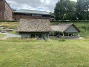
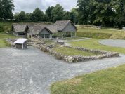
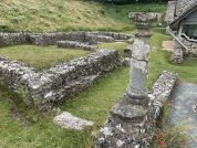
Roman Town House
Dorset County Council acquired Colliton Park in 1933 as the site for the construction of County Hall. The Town House was discovered in 1937/38 during an archaeological investigation carried out by the Dorset Natural History and Archaeological Society prior to the construction of the new building. Plans for County Hall were modified so that the Town House could be retained on site.
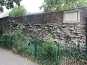
The Town House is a scheduled ancient monument and a Grade I listed building. It is bounded on the north and west sides by North Walk and West Walk which are also scheduled monuments having the remains of the Roman ramparts of the town just below surface level.
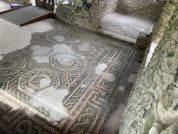
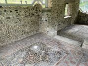
The Town House has two principal ranges of rooms. The South Range comprising rooms 1–7 survives in the plan form of flint and stone walls on the grass covered site. The West Range comprising rooms 8–18 was mosaic floored. This range was re-excavated and provided with a steel and glass cover building with a stone tiled roof all perched on the original foundations between 1996 and 1999.
Other Excavations
Excavations were also conducted at several locations throughout the town in 1970:
- The south defences were sectioned near the south-west corner-angle at Bowling Alley Walk (SY691903), revealing that the rampart had been built in at least two phases; the first rampart was of dumped-chalk 50ft (c.15m) wide, which was later augmented by an earth-bank at least 90ft (c.27m) wide; no trace of the town wall was found. The south-west corner-angle was also investigated during surface-stripping of the Great Western Road nearby, revealing that the defensive ditch system was at least 250ft (c.75m) wide.
- Investigations in the grounds of Dorchester Hospital and at West Walk (SY690904) revealed a sequence of cobbled roads, a covered walkway and several 4th century buildings.
- A Roman road running east-west was uncovered at Greenings Court (SY694908) which was first laid in the 1st-century and was resurfaced three times, the last resurfacing occurring in the late-4th. A fence bordered the northern side of this road, delineating the grounds of a large timber building of the 1st century. The area was later used as a rubbish dump, the demolished remains of a hypocaust system being tipped here during the 3rd.
- In addition, a two-roomed masonry building was discovered in the grounds of Dorchester Gaol (SY691908).
Classical References to Durnovaria (Dorchester)
The first classical mention of the name for the Dorchester Roman settlement occurs in the Antonine Itinerary of the late second century. The fifteenth (and last) itinerary deals with south-west England, and details the road-route between Calleva (Silchester, Hampshire) and Isca Dumnoniorum (Exeter, Devon). In Iter XV the station Durononvaria is listed 8 miles from Vindocladia (Badbury, Dorset) and 36 miles from Muridunum (nr. Honiton, Devon). This entire itinerary has been mistakenly copied onto the beginning of Iter XII at sometime in the distant past.
The final mention of Roman Dorchester possibly occurs in the Ravenna Cosmology of the seventh century, where the name Purocoronauis (R&C#6) is listed between Tamaris (Plymouth, Devon) and the unidentified station Pilais. This station has also been identified with the Dumnonian hillfort at Carn Brea in Cornwall.
The earliest classical work which details the geography of Roman (i.e. post-Iron-Age) Britain is that of Claudius Ptolemaeus which was produced in the early-second century. Ptolemy gives the name of only a single town in the territory of the Durotriges, named Dunium, which has been equated with the captured hillfort at Hod Hill. This perhaps indicates that the Durotriges were under Roman military jurisdiction for quite some time before their own tribal administrative centre was established, also perhaps, that Roman rule over the tribe was administered from the auxiliary fort built in the north-west corner of the old hillfort.
References for Durnovaria (Dorchester)
- The Towns of Roman Britain by John Wacher (2nd Ed., BCA, London, 1995) pp. & fig.145;
- Britannia ii (1971) pp.279, 281 & graffito p.295; The Roman Inscriptions of Britain by R.G. Collingwood and R.P. Wright (Oxford 1965).
Roman Roads near Durnovaria (Dorchester)
NNW (23) to Ilchester WNW (34) to Whitley Castle (Whitley Castle, Northumberland) ENE (19) to Vindocladia S (5) to Jordan Hill (Dorset) SW (2) to Maiden Castle ENE (19) to Shapwick NNW (19) to West Coker WNW (34) to Mvridvnvm
Sites near Dorchester (Durnovaria) Roman Settlement
- Dorchester (Durnovaria) Ampitheatre (1 km)
Amphitheatre - Maiden Castle Temples (3 km)
Temple Or Shrine - Maiden Castle (3 km)
Iron Age Hillfort and Neolithic Causewayed Enclosure - Jordan Hill Temple (9 km)
Temple Or Shrine - Black Down (9 km)
Possible Roman Camp - Dewlish Villa (10 km)
Villa - Abbotsbury Hill Fort (14 km)
Iron Age Hillfort - Wareham (23 km)
Minor Settlement - Hod Hill (Hillfort) (26 km)
Iron Age Hillfort - Hod Hill (Dunum) Roman Fort (26 km)
Claudian Auxiliary Fort (AD 43–54)