Weir Gardens Temple
Villa
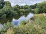
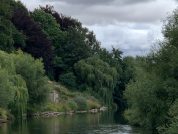
The Weir Gardens remains are the largest upstanding Roman remains in Herefordshire and represent a type of riverside building that is unique in this country. The visible remains consist of two large stone ‘buttresses that jut out into the River Wye from a large terrace that appears to have been cut into the river bank. Next to the north buttress several large blocks were recorded and are thought to be the remains of large stairs leading down to the water’s edge. Small sections of wall and piles of roof tiles were also seen sticking out from the bank below the terrace. The trenches uncovered a small room and doorway on top of the north buttress.
Trenches recently dug on the terrace revealed a mosaic floor near the buttresses and there was evidence of stone walls but most of the trenches contained a lot of Roman rubble. There was also a geophysical survey of the site which suggested that the rubble spread out across the whole terrace.
It has been suggested that the ruins of the New Weir site represents a high-status Roman villa complete with terraced gardens and a nymphaeum, a Romano-British shrine devoted to the water nymphs which inhabited the River Wye. We do know though that it would have been a multi room residence with columns, beautiful mosaic floors and steps down to the river edge. Limited finds from the site have permitted a rough period of occupation around the third or fourth centuries.
RIB 303 - Altar dedicated to Silvanus
To the god Silvanus ..
SILVAṆO
[.]S[...]
[...]
[...]
[...]
It may have come from the Roman town at Kenchester.
It is possible that the Roman altarstone found in 1821 beneath the Billiard Hall beside the Hereford Public Library and recorded in the R.I.B. may have originally come from the Wier Gardens site. This stone is heavily damaged with the last four lines being completely obliterated, but the name of the god is discernable – Silvanus was the Roman god of the natural open countryside and an ideal candidate for inclusion among the deities worshipped at this suspected Temple here on the banks of the Wye.
The Octagonal Cistern or Water Tank

Almost the first thing the visitor notices upon entering the National Trust gardens is the octagonal cistern close to the left of the path. This was discovered by workmen digging a trench for a new water pipe in 1891, who unfortunately removed several of the upper stones before the nature of the stonework was realised, and did not replace them back in their correct positions. This explains the stone water-tank’s less than perfect outline. Despite the fact that the central opening in the lowest stone was found to be plugged with tesserae, the original excavators did not believe that the remains were Roman, and assigned to it a medieval date.
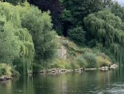
The Northern Buttress

A short distance north of the cistern two massive buttresses intrude into the stream of the Wye. The northernmost of these structures remains over 4m in height from its base, making it the tallest free-standing Roman structure in Herefordshire. The base of this buttress is constructed of several massive stone blocks of at least four courses cemented together, upon which are several more courses of smaller finely-dressed stones. The structure is badly damaged by erosion at its western corner, where all of the upper courses have been lost, thus exposing the rubble and mortar infill of the buttresses core. At this point, several “lewis holes” are visible in the larger foundation blocks, which were used both for lifting the massive stones and to fix them in place.
The Southern Buttress
The southernmost Roman buttress is almost completely destroyed by natural erosion. There is a spring in the gardens here which emerges from the spring line in the terrace about twenty-or-so feet above the level of the River Wye and was evidently incorporated within the structure of the buttress itself. It is very likely that this contributed heavily to the deterioration of this particular Roman structure. The spring water evidently contains a large amount of dissolved minerals as the southern buttress has now been replaced by a very natural-looking mound of calcified deposits, over and through which runs a little rivulet of clear fresh water. It was observed that there is a calm area in the surface waters of the river below this lower intrusion, which would have made an excellent “landing-stage” for the villa/temple complex above, although no evidence has been found to support this.
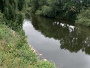
Massive Roman Masonry Blocks in the Wye
The bed of the River Wye is here strewn with many large, dressed stones measuring around three or four feet on a side, each of which must weigh many tons. These huge pieces of masonry must have been transported here from some unknown Roman quarry along the River Wye itself. During our visit in early Spring the Wye was yards lower than its Wintertime flood level, and its waters crystal-clear, many Roman stones being apparent just below the surface. These massive stones were seen deposited on the river bed immediately opposite the two buttresses and also further downstream opposite the octagonal water-tank. They must have originally formed part of a large building set back into the riverbank terraces between the two buttresses, and also incorporated into a substantial structure in the area of the cistern.
The water from the spring in the southern buttress is depicted on the excavation plans of 1977 as flowing directly towards the River Wye, and this is exactly what is currently observed at the site, the water obviously taking the path of least resistance. Upon descending to the level of the river in order to more closely observe the effects of erosion on the Roman structures, Peter and myself observed what at first appeared to be a ceramic box-flue of the type used in Roman bath-houses. This was embedded in the bank of the southern buttress buried some three feet below the current ground level and evidently exposed during recent subsidence.
Upon closer examination this was found to be the remains of a wooden chute, probably used to direct the flow of the spring above, and angled by about 45° from the more direct modern run-off. The structure was about a foot across with sides of around four inches, forming a shallow U-shaped channel. The calcium deposits in the water had evidently built up over the years, completely surrounding the wooden trough which had rotted away during the time it remained buried. The area immediately below the spot where the chute protudes is strewn with pieces of Roman building material including bits of broken tile, several tesserae and a piece of green-painted wall plaster.
The entire site is under threat from the River Wye which often floods up to the level of these Roman remains, and therefore has the potential to severely damage the archaeology. Last year (2001) several tons of hefty stones were laid about the base of the Roman structures on a carpet of fibre-glass in an effort to reduce the effects of erosion, but it was seen during our short visit that these expedients are mostly ineffective, and surprisingly large areas of this covering have been washed away over the course of just one year. Now exposed to the elements by the eroding effects of the fast-flowing river, the survival of the recently discovered Roman water-chute depends on the rapidity in which effective rescue operations can be arranged.
The Weir Gardens Related Links
References for The Weir Gardens
- The Roman Inscriptions of Britain by R.G. Collingwood and R.P. Wright (Oxford 1965);
Map References for The Weir Gardens
NGRef: SO4341 OSMap: LR148/149/161
Roman Roads near The Weir Gardens
Probable Trackway: N (0.5) to Magnis (Kenchester, Herefordshire)
Sites near Weir Gardens Temple
- Sutton Walls Hill Fort (10 km)
Iron Age Hillfort - Blackwardine Roman Settlement (18 km)
Minor Settlement - Capler Camp (18 km)
Iron Age Hillfort - Clifford Roman Fort (19 km)
Neronian Auxiliary Fort (AD 54–68) - Canon Frome (Stretton Grandison) Roman Fort (20 km)
Claudian Auxiliary Fort (AD 43–54) and Minor Settlement - Clyro Vexillation Fortress (21 km)
Vexillation Fort - Boatside Farm Temporary Camp - Clyro (21 km)
Marching or Temporary Camp - Twyn y Gaer Hillfort (Llanfihangel Crucorney) (24 km)
Iron Age Hillfort - Burfa Camp (24 km)
Iron Age Hillfort - Pyon Wood Camp (25 km)
Iron Age Hillfort