Welwyn Settlement
Major Settlement
This major roadside settlement was only eight miles to the north-east of Verulamium (Saint Alban’s, Hertfordshire), the civitas of the native iron-age tribe the Catuvellauni, in whose territories Welwyn was obviously situated. The settlement lay on the initial stretch of a major Roman road which linked Saint Alban’s with Camulodunum (Colchester, Essex) the former capital of the Trinovantes and briefly the base for the Twentieth Legion. The next station on this road was Braughing in Hertfordshire, some twelve miles further north-east. There is no record of any Roman military activity in the immediate area of the Welwyn site.
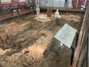
The settlement is known mainly from chance finds made during building work in the modern town. There is occupation evidence to either side of the probable line of the Roman road to the north-east and south-west of its crossing with the Mimram Brook. Sparse scattered finds have indicated an occupation from the late-first to the fourth centuries. Structural finds include stone and timber-lined wells, T and Y-shaped ovens, storage pits containing carbonized cereals, and the remains of at least one substantial building. A cemetery positioned to the west of the road, north of the stream crossing, contained cremations and inhumation burials ranging from the first to the third centuries.
One grave, was probably of a wealthy local chief and dates back to 50 to 10BC., and is displayed in the British Museum. The grave demonstrates that luxury goods were being imported from the continent between the invasions of Cesar and Claudius.
There is a Roman villa nearby at Lockleys (TL2316), about 800m east of the settlement, and another suspected villa at Dicket Mead about 600m to the east.
References for Welwyn
- Victoria County History – Hertfordshire (vol.IV, p.165)
- Historical Map and Guide – Roman Britain by the Ordnance Survey (3rd, 4th & 5th eds., 1956, 1994 & 2001);
- Roadside Settlements in Lowland Roman Britain by Roger Finch Smith (BAR#157, 1987) p.232/3, fig.15.
Map References for Welwyn
NGRef: TL2316 OSMap: LR166
Roman Roads near Welwyn
N (12) to Baldock NE (12) to Bravghing SW (8) to Vervlamivm (St. Albans, Hertfordshire)
Sites near Welwyn Settlement
- Welwyn Roman Baths (0 km)
Bath House and Villa - Dicket Mead Roman villa (0 km)
Villa - Lockleys Roman villa (1 km)
Villa - Wheathampstead Hillfort (5 km)
Iron Age Hillfort - Saint Albans (Verulamium) Fort (13 km)
Claudian Auxiliary Fort (AD 43–54) and Flavian Auxiliary Fort (AD 69–96) - St Albans (Verulamium) Theatre (13 km)
Theatres - St Albans (Verulamium) Roman Settlement (13 km)
British Capital and Flavian Auxiliary Fort (AD 69–96) - Verulamium Hypocaust and Mosaic (13 km)
Roman Houses - Gorhambury Rural Villa (14 km)
Villa - Park Street Villa (15 km)
Villa


