Discovering Roman Norfolk
Although Claudius’s invasion in AD 43 established the Roman province of Britannia across much of lowland Britain, the Iceni tribe retained their independence for nearly two more decades. The Roman period in Norfolk and the broader Icenian civitas (which included parts of north Suffolk and the eastern fens) truly began in AD 61, following the defeat of Boudica’s revolt. This delay in Roman control suggests potential early military activity, though evidence is limited to a few confirmed forts and temporary camps, such as those at Swanton Morley, Saham Toney, and Horstead with Stanninghall. Many other rectilinear enclosures with fort-like features are likely civilian settlements.
The Roman Landscape
The topography of Roman Norfolk differed significantly from today’s landscape. A large estuary covered the Halvergate and Breydon Water area, with open sea reaching as far inland as Acle. Rivers were wider, deeper, and more navigable, while coastal erosion and land reclamation have altered the former shoreline. The fenland to the west, initially marshy, became dry enough in the early Roman period for settlement and farming. This area was part of a vast Imperial Estate, administered from Stonea in Cambridgeshire, and included prosperous fen-edge villas like those at Feltwell and Methwold. Low-status settlements in the fens were engaged in salt production, peat cutting, and livestock farming.
Towns and Urban Centres
The Roman town of Venta Icenorum at Caistor St. Edmund (Venta Icenorum) was established around AD 70, likely replacing an earlier Icenian settlement and possibly a Roman fort. It served as the administrative, legal, and economic centre of the civitas, featuring a planned street grid, public buildings like a forum and basilica, baths, temples, and townhouses. Defensive walls were added in the late 200s, enclosing about half of the town and leaving its suburbs and a major pagan temple complex undefended.
A second town at Brampton Roman, 20 kilometres north of Venta Icenorum, was a significant industrial centre. Its extra-mural area housed 132 kilns producing pottery for local and regional use. Other substantial settlements, often located at river crossings or crossroads, functioned as markets, industrial hubs, and religious sites. Recent excavations at Scole and Billingford have shed light on these multi-purpose settlements.
Rural Settlements and Villas
Until recently, Roman villas were thought to be concentrated along the fen-edge and in northwest Norfolk, but new discoveries suggest a more widespread distribution. In addition to villas, roundhouses and aisled barns are increasingly being identified. Excavations at farmsteads in Snettisham, Downham Market, Brettenham, Kilverstone, and Watlington are providing insights into the origins, development, and functions of these rural settlements. Fieldwalking surveys indicate a density of 0.5 to 1.0 sites per square kilometre, with over 8,000 Roman sites and finds recorded across Norfolk.
Religious and Funerary Practices
Religious activity in Roman Norfolk is evidenced by artefacts and placed deposits, though few temples or shrines have been identified. Known religious sites include those at Caistor St Edmund, Hockwold, Crownthorpe Temple (Wicklewood), Snettisham, and Thetford. Surprisingly, only around 200 Roman cremation and inhumation burials have been discovered, suggesting many cemeteries remain undiscovered.
Industry and Economy
Industrial activity was widespread, with major pottery production centres at Brampton and in the Nar Valley (Pentney, Shouldham, and Middleton). Smaller-scale industries included salt production, metalworking (iron and bronze), coin minting, and brooch manufacturing. The fenland also supported extensive salt-making and peat-cutting activities.
Military Presence and Coastal Defences
In the early 200s AD, military supply bases or depots were established at Branodunum (Brancaster) and Caister-on-Sea. These, along with the slightly later fort at Gariannonum (Burgh Castle), formed part of the Litus Saxonicum (the Saxon Shore], a chain of coastal defences against barbarian raids. Smaller posts and lookouts likely existed along Norfolk’s long coastline.
Hoards and Late Roman Instability
Coin hoards from the 200s and 300s AD reflect the growing instability of the later Roman period, with perceived or actual threats to people and property. Other hoards, such as those containing metal vessels (Hockwold and Crownthorpe) and jewellery (Snettisham), further illustrate the uncertainties of the time.
Population and Cultural Continuity
The Roman landscape of Norfolk was largely cleared and farmed, supporting a population of several hundred thousand. While many inhabitants were of indigenous descent, the extent of their “Romanisation” varied. Some likely continued to follow ancient customs and speak Celtic dialects, even towards the end of the Roman period.
Post-Roman Transition
The extent to which Roman settlements coexisted with Anglo-Saxon communities after AD 410 remains unclear. Investigating the transition and continuity during the 5th century AD is a key research priority, as it holds the potential to shed light on this transformative period in Norfolk’s history.
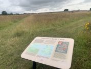
Roman Sites to Explore in Norfolk
Caistor St Edmund (Venta Icenorum)
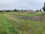
Caistor St Edmund Roman Town, also known as Venta Icenorum, was the largest Roman settlement in East Anglia. Initially established in the AD 70s, the town was unenclosed, with the banks and walls that are visible today not constructed until the 3rd century AD. Designed around a grid of streets, the town featured hallmark Roman structures, including an amphitheatre to the south of the walled area and a temple to the northeast, in addition to those at its center. It also boasted running water, public baths, a town hall (basilica), and a central forum.
The site remained occupied into the early Anglo-Saxon period, with evidence of habitation continuing into the early 6th century. However, the Roman buildings and infrastructure were left to deteriorate over time. By the 8th century, Venta Icenorum was abandoned as Norwich emerged as the region’s civic center. Unlike most Roman towns, it was never built over in later centuries, making it one of only three such sites in the country. This unique preservation offers an exceptional opportunity to study its below-ground archaeology.
Read more about the Caistor St. Edmund (Venta Icenorum) Roman TownBrancaster Roman Fort
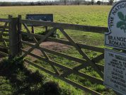
In the 1830s, cropmark evidence first brought attention to the location of the Branodunum (Brancaster) Fort, and subsequent excavations uncovered Roman artifacts and materials. It is believed that the fort, likely built between 225 and 250 AD, replaced an earlier structure. The garrison consisted of units from Gaul and Dalmatia. Artifacts found within the fort suggest it was occupied during the third and fourth centuries AD. The fort’s layout follows a typical design, positioned on a ridge with a rampart enclosure, a stone wall, and surrounding ditches. Each of the four walls has a central gateway, with connected guard chambers, and each corner of the fort is rounded with internal turrets.
Over time, the fort’s walls deteriorated and were demolished in 1770. The materials were then repurposed in the construction of the Great Malthouse at Brancaster Staithe (NHER 1377).
Artifacts recovered from the fort include a silver ring, a knife, bone and ivory pins, deer antler, tiles, pottery, coins, and oyster shells. Oysters were a common part of the Roman diet, as they had a strong preference for fish. The presence of oyster shells during fieldwalking is often a reliable indicator of Roman activity in the area. Additionally, an excavation revealed the remains of six or seven individuals, including a child. A gold ring was also discovered, featuring two heads and an inscription reading VIVAS IN DEO (“live in God”), suggesting Christian origins.
Read more about the Branodunum (Brancaster) Roman FortCaister on Sea Roman Fort
A Bronze Age ring ditch, a Roman bridge, a corn drying kiln, a drain, floors, hearths, a hypocaust, a mausoleum, lime works, an inn, and a fort have all been discovered at Caister-on-Sea. Excavations began as early as 1837 when skeletons, coins, and pottery sherds were uncovered in a pit lined with Roman tiles, continuing through to 1997. The fort itself was originally positioned along the shoreline of a large estuary that extended inland to the south. Today, what remains are the western section of the fort’s interior and parts of its defensive structures. The fort was likely divided into a rectilinear grid of streets. Its construction dates back to the early third century AD, with artifacts ranging from military equipment to personal items such as hairpins, indicating the presence of women in the fort, possibly from the late third century onwards.
By the late second century AD, southeastern England’s coastline faced increasing threats from Saxon raiders, prompting the construction of defensive structures, much like those found elsewhere in Roman Europe. A defining characteristic of these shore forts was their formidable stone walls, reinforced by an inner earth mound and surrounded by ditches. Parapets and turrets would have been positioned at regular intervals along the fortifications.
The Caister-on-Sea fort follows a relatively typical shore-fort design. The wealth of archaeological evidence found within its remains has been invaluable in dating the site. Since few shore forts have survived, those that remain are of national significance, offering crucial insights into Roman strategic military policies during their occupation.
Read more about the Caister on Sea Roman FortBurgh Castle Roman Fort
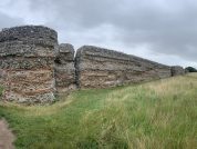
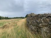
Burgh Castle Roman Fort is one of Britain’s most well-preserved Roman sites and the most prominent landmark in the area. Built in the late 3rd century, it was part of the Saxon Shore Fort system, a network of coastal defenses designed to protect against Saxon incursions. Known as Gariannonum during the Roman period, the site later became Burgh Castle, with “Burgh” deriving from the Old English word for a stronghold or fortification.
Perched on the edge of the Broads, the fort overlooks the River Waveney, offering panoramic views of the surrounding landscape. Though its fourth wall collapsed into Breydon Water long ago, the remaining massive stone walls stand largely intact, providing a remarkable example of Roman military engineering. Just beyond the fort’s walls, aerial photographs reveal the probable site of a Roman vicus, a civilian settlement, along with evidence of a Roman field system excavated by the Norfolk Archaeological Unit.
A wealth of Roman artifacts—including coins, pottery, brooches, and personal items such as rings—offers insight into the daily lives of those who lived, worked, and farmed in and around the fort. Today, visitors can walk along the walls, explore its rich history through different phases of use, and appreciate the peaceful natural setting that surrounds this historically significant site.
Read more about the Burgh Castle (Gariannonum?) Roman Fort


