Chanctonbury Ring Hill Fort
Iron Age Hillfort and Temple Or Shrine

Situated on the northern edge of the South Downs, Chanctonbury Ring occupies a very prominent position (maximum height approximately 234 m above sea level) with extensive views northwards across the Weald to the North Downs, and southwards over a considerable stretch of coastline.
Hill Fort at Chanctonbury Ring
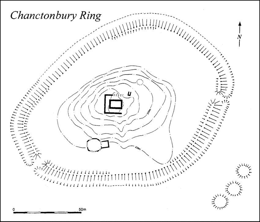
A small pear-shaped Iron-Age Hillfort dating to 400 – 300BC. It has a single rampart of dump construction, and an external ditch, with some extra defences to the west and east, and a simple entrance gap on the south-west. It has a single rampart of dump construction, and an external ditch, with some extra defences to the west and east, and a simple entrance gap on the south-west. The approaches along the spur to the west and south-east are barred by cross-dykes, positioned some 440 yards (400m) away from the main defences. Dating evidence was provided by pottery shards and refuse pits; an animal bone found on the site was dated through radiocarbon dating to around 370 BC. However, later analysis of pottery finds suggests that its origins are significantly older and may date to the late Bronze Age, or around the seventh century BC. Chanctonbury Ring appears to have been abandoned some time around the mid-fourth century BC.
The Roman Temples at Chanctonbury Ring
Around five hundred years after its initial abandonment, Chanctonbury Ring was reused as a religious site from the mid-first century AD.

Chanctonbury Ring – Temple 1 – Romano – Celtic shrine
The larger of the two known temples was constructed on a west-east alignment in the centre of the fort, at the highest point on the site. It had a “rectangular central cella or inner chamber” measuring about 9 metres (30 ft) by 7 metres (23 ft). An ambulatory or enclosed covered walkway enclosed it on the west, north and east sides, and was paved with a “rammed chalk floor” around 3 metres (9.8 ft) wide. The ambulatory’s external wall was covered with red-painted plaster. The building was entered from the east, aligning it with the original entrance to the hill fort.
A small rectangular structure stood about 5 metres (16 ft) from the north-east corner of temple. Constructed on a NNE-SSW axis, it measured about 3 metres (9.8 ft) by 1 metre (3 ft 3 in). This has been interpreted as an oven or furnace. A large circular rubbish pit was constructed nearby. It has provided a variety of datable finds, including roof tile fragments, “window glass, oyster shells, pottery sherds and coins”, analysis of which has shown that the temple was in use during an approximately 350-year-long period from the mid-first to the late fourth centuries AD. It is not known which deity the temple was dedicated to.
Chanctonbury Ring – Temple 2 – Polygonal Temple
A second temple was located around 30 metres (98 ft) southwest of the first. Its remains are much more fragmentary as it appears to have been dismantled after falling out of use. It appears to have had a polygonal shape, measuring about 8 metres (26 ft) on each side, with a rectangular annexe on the eastern side which had a floor made of tessellated greensand cubes. The temple may have been dedicated to a boar cult, judging from the discovery of numerous bone fragments from the heads and jaws of pigs. A copper alloy plaque of a boar found at nearby Muntham Court Romano-British site may have been associated with the cult.
Why were the Temples built here?
It is not known why the Roman temples were built on the site, but there are examples elsewhere of the Romans building on the site of Iron Age temples or shrines. However, it is more difficult to argue for this being the case at Chanctonbury Ring, given the gap of half a millennium between the hill fort’s abandonment and reoccupation. In other locations, such as at Hayling Island and Maiden Castle, there was continuity of religious use between Iron Age and Roman times, which was clearly not the case with Chanctonbury.
The hill fort’s rampart may have been refurbished when it was reoccupied, and at least one of the two nearby dykes was probably also constructed during the Roman period. The excavation of 1909 also reportedly found the remains of a “curious pear-shaped structure”, but subsequent archaeological investigations have revealed no evidence of it. The site is linked via a Roman terraceway on the north face of Chanctonbury Hill to the Sussex Greensand Way, which runs parallel to the northern escarpment of the Downs.
Mosaic fragments from Chanctonbury Ring can be found at the Horsham Museum.
Map References for Chanctonbury Ring – Washington, Sussex
NGRef: TQ139121 OSMap: LR198
References for Chanctonbury Ring
Chanctonbury Ring revisited – https://archaeologydataservice.ac.uk/archiveDS/archiveDownload?t=arch-285-1/dissemination/pdf/vol_139/03_rudling.pdf
Plan of Chanctonbury Ring Hill Fort
Sites near Chanctonbury Ring Hill Fort
- Chanctonbury Ring Temples (0 km)
Temple Or Shrine - Findon Temple (5 km)
Temple Or Shrine - Lancing Down Temple (7 km)
Temple Or Shrine - Hardham Roman Settlement (12 km)
Mansio and Minor Settlement - Hurstpierpoint (14 km)
Pottery and Villa - Bignor Roman Villa (15 km)
Villa - Hassocks Cemetary (16 km)
Cemetery - Novus Portus (Brighton)? (19 km)
Probable Port - Alfoldean (21 km)
Mansio and Minor Settlement - Chichester (Noviomagus Reginorum) (29 km)
British Capital and Port


