Piercebridge (Morbium) Roman Bridge
Roman Bridges
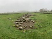
The main Roman Road from York to the north of England crossed the River Tees at Piercebridge. Portions of the Roman Bridge were found in 1972 in advance of gravel quarrying.
The River Tees has moved course to the north since the bridge was in use. Only the lowest elements of the bridge survive. At the base was a wash way of large irregular flagstones which made the water flow smoothly under the bridge arches. On this were built the piers which carried a timber roadway. These have been disturbed by flood water. The south abutment of the bridge survives to a height of two courses. It is built as the piers must have been of the large stones joined with iron cramps to resist the force of the river.
The stone piers and abutments supported a roadway of timber beams and planks.
The bridge was probably built in the latte half of the second century, but quite soon the course of the river began to move to the north and the southern end of the bridge began to silt up. Remains of a causeway and its revetmen wall, built out over these layers of silt, in order the prevent subsidence of the land and carrying the road towards the part of the bridge which still crossed the river can be seen at the southern end of the site.
Piercebridge & Dere Street
Dere Street was constructed as the Roman army advanced north during the latter years of the first century AD. That road was carried over the River Tees at Piercebridge where the Romans built a substantial bridge over the fast flowing river.
The Prehistoric Bridge at Piercebridge
Channel 4’s Time Team investigated Piercebridge in 2009 and found evidence for a prehistoric bridge located here. It was probably repaired later suing Roman concrete. Underwater exploration found a number of timbers to the west of the course of the Roman stone bridge, and a radiocarbon date in the 1st century AD was obtained for an additional line of timber piles to the west of this.
The First Roman Bridge at Piercebridge
The army built a replacement, this time from stone, several hundred metres downstream and it is these remains which can be seen today. The main bridge structure was again of timber, but this time the timber was supported by stone abutments and a series of five thick masonry piers. The builders also laid down a series of paving blocks in the river bed to prevent the river from damaging the piers.
Over time the river continued to change course, moving gradually northward. The southernmost abutment silted up in the 4th century, so the Romans built a metalled causeway leading to the bridge, protected by a retaining wall of limestone blocks.
The second Roman bridge was probably built at the same time as the 3rdt Century Roman Fort.
Visiting the Roman Bridge at Piercebridge
The stonework foundations are all that remain of the bridge that once carried the Roman Road, Dere Street, across the river Rees and on towards Piercebridge. There is free parking available in the car park of the nearby George Hotel. Walk to the back of the car park, alongside the main road and you will see a stile to a lane, which leads to the Roman Bridge.
Finds in the River
some interesting deviation from the coin assemblage recovered from the earlier excavations, suggesting a different pattern of coin loss and therefore, by inference, function. The structure of the assemblage as a whole is more in keeping with votive offerings rather than everyday loss and discard. In particular, while the excavations have not recovered any coinage prior to the resign of Vespasian (69-79AD), there are a number of earlier coins from the river. The river assemblage shows two peaks in distribution, the first around138-161AD and the second around 193-222AD. The high incidence of coins dating from the second half of the 3rd century AD from the excavations is not mirrored in the river assemblage. This decline in the deposition of late coins is also seen at other votive sites.
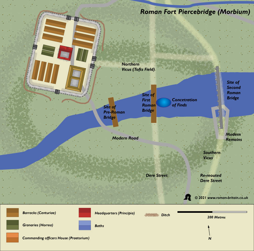
Plan of Piercebridge (Morbium) Roman Bridge
Sites near Piercebridge (Morbium) Roman Bridge
- Piercebridge (Moribum) Vicus (0 km)
Vicus - Piercebridge (Morbium) Roman Fort (0 km)
Auxiliary Fort - Holme House Villa (1 km)
Villa - Holmes House Roman Fort (1 km)
Trajanic Auxiliary Fort (A.D. 98–117) - Stanwick Camp (5 km)
Iron Age Hillfort - Sandforth Moor Temporary Camp (6 km)
Marching or Temporary Camp - Cleasby Roman Fortlet (6 km)
Fortlet - Carkin Moor Roman Fort (9 km)
Auxiliary Fort - Greta Bridge Vicus (13 km)
Vicus - Greta Bridge Roman Fort (13 km)
Trajanic Auxiliary Fort (A.D. 98–117)


