Reculver (Regulbium) Fort
Saxon Shore Fort
Regulbium was the name of an ancient Roman fort of the Saxon Shore near the English resort of Reculver in Kent. When built the Roman fort stood at between one and three km inland. It is said to have stood on a promontory which pushed out into the Thames estuary and carried a signal station or even lighthouse before coastal erosion took its toll. The far east side of the fort drops down to the marshy flood plain of the River Wantsum/Wantsum Channel which, once upon a time, cut Thanet from the mainland. This river enabled small boats to pass between to Reculver, Richborough, Hoath, Fordwich and Canterbury in Roman times as Reculver was an early Claudian bridgehead.
The Roman Signal Station at Reculver
One of the original Claudian bridgehead constructs; a small defended area of about an acre was probably a signal station, or even a lighthouse, situated at the northern entrance to the Wansum Strait, and indicating the importance which the Roman military attached to this supply route. No precise dating evidence has been found, but coins of Tiberius and Nero in mint condition suggest that this initial military site was maintained until at least c.65AD.
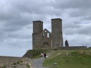
The Saxon Shore Fort at Reculver
Reculver was a square fort with walls 10 feet thick at the base, 8 feet thick above offsets ; the corners were rounded and no bastions are known, nor are there any bonding-courses. One gate is known, in the centre of the west wall. There is said to have been a ditch once visible. The internal area seems to have been about 7½ acres. Measuring about 10 feet (3m) wide at the base with two offsets tapering to about 8 feet (2.5m) wide at the top, and backed by an internal earth rampart, the fort walls would originally have been some 20 feet (6m) high. Two external ditches have been noted, the inner some 2.7m in depth and 7.9m wide, and the outer c.2m deep and 5m across.
The south wall is quite substantial, it runs along the lane which runs east and turns round a rounded corner into the east wall where two defensive ditches used to be. The wall, may have stood as high a 6 metres and backed with an earth rampart inside. It is made of black flints (from Thanet) and ragstone set in concrete or mortar without, for some reason, the usual red tiles of levelling or bonding courses usually associated with Roman walls. The eastern wall shows signs of repair; behind the repair were found the remains of a Roman oven. The wall enclosed an area of some 5 acres. The 15th century Saxon church wall addition contains red bricks/tiles robbed out from later Roman building. Little of the ashlar blocks (facing stones) remain but they are visible here and there as at the bottom of the wall in image (10). Some material for the stone fort may have come from Bishopstone Glen (between Reculver and Herne Bay – click here for more) but the ragstone is much more likely to have come from the quarries at Maidstone .
In the centre of the east wall a gap reveals the 2.7m wide east gate which is still used to this day as a pathway into and out of the fort area (the via Principalis) and still existing are the overgrown foundation stones of a sentry or guard box (6) next to it. This is just about as much can be easily seen today.
The plan of the sit shows the fort had a principia (containing an underground strong room or sacellum), a basilica, two barrack buildings and a couple of hypercausted buildings, probably bathhouses. All around the fort signs were found of a vicus as one might expect (and presumably on the now eroded north side as well.)
The Regulbium Garrison
There are references to Cohors I Baetasiorum (CIB) – The First Cohort of Baetasii (Tribunus cohortis primae Baetasiorum, Regulbio) in the 4th/5th century document – the Notitia Dignitatum.
“The tribune of the First Cohort of Baetasians at Regulbium.” (Notitia Dignitatum xxviii.18; 4th/5th C.)
This is further supported by the discovery of tiles stamped with the initials “CIB”.
The regiment is a cohors peditata quingenaria, a unit of foot soldiers nominally five-hundred strong, which were originally recruited from among the Baetasii of Lower Germany; this tribe inhabited the lowlands between the Maas and the Rhine, their capital city being Novaesium now Neuss in modern West Germany. There may also have been marines of the Classis Britannica as well for protection against coastal pirates in later times. The Cohors I Baetasiorum were previously stationed at Maryport, in Cumbria, and, since they probably built the fort at Reculver, this may explain the similarity between it and the forts along Hadrian’s Wall.
The Reculver Stone Inscriptions
There were four inscriptions found, however only the following is useful.
RIB 3027 - Fragmentary building inscription - Reculver (Regulbium)
The shrine of the headquarters building with its cross-hall, under […]ius Rufinus, the consular governor, […] Fortunatus […].
CV[]ASILICA ▸
SV[..]Ṛ.[.]IO RVFINO
[vacat ] COS ▸ vacat
[...]TVNATVS
[...]T ▸
1. aedem p[rinci]piorum was convincingly restored by Richmond, a term previously unattested. RIB 1912 (Birdoswald) first distinguished principia (headquarters building) from praetorium (commandant’s house), and aedes alone has since been restored in RIB 3079 (Caerleon, site of the basilica principiorum). 2. cu[m b]asilica. The first explicit identification of the headquarters building cross-hall as the basilica. 3. The governor’s name is uncertain. The problem is well discussed by Birley, but his suggestion of L. Prosius Rufinus (legate of Thrace, 222) is excluded by the bottom serif seen by Richmond after the first R. Richmond himself suggested A. Triarius Rufinus (cos. ord. 210), but was forced to insert a diminutive I between R and I: the draughtsman of this text seems to have resorted to such expedients only towards the end of the line, and it is unlikely, but not impossible, that an early third-century consul ordinarius should have next governed a military province. The best suggestion is by Harper, of Q. Aradius Rufinus (acting proconsul of Africa, perhaps in 238). 4. COS has evidently been centred. The term consularis for the governor of Britain is already used informally by Tacitus in 98 (Agric. 14), and in contemporary documents from Vindolanda (Tab. Vindol. II, 225.15, II, 248.9–10, II, 295.5; III, 581.96); also on an altar (RIB 1809) in c. 163. In building inscriptions it is first applied to Septimius Severus’ governors, and since they are all known, the consularis Rufinus is probably a third-century governor of Britannia Superior. 5. [… Fo]rtunatus. Otherwise unknown, but presumably the unit-commander. His cognomen was preceded by his nomen and probably his abbreviated praenomen. 6. […]T. After T there was apparently a stop: it was read by Wright, and drawn by Richmond. Like the stop after COS, it would imply abbreviation (the stop after BASILICA being no more than a space-filler), but Richmond took T to be the last letter of a verb, with Fortunatus as its subject. Wright actually read […]IT, by implication for [fec]it but it was not drawn by Richmond, and the photograph shows only damage here; at most there was only the tip of a serif just as appropriate to E. A verb would be redundant, and it is more likely that the line contained Fortunatus’ rank or post; he was probably prefect or acting-prefect of the First Cohort of Baetasii, which seems to have built the fort (compare RIB II.4, 2468) and remained in station. So a likely restoration is [PRAEF COH I BAE]T, [praef(ectus) coh(ortis) I Bae]t(asiorum).
Raculf – Saxon Minster
There are two references to Reculver in the Saxon Chronicle of the twelfth century, where it both times appears as Raculf:
A.D. 669. This year king Egbert gave to Bass, a mass-priest, Raculf to build a minster upon.
A.D. 690. This year archbishop Theodore, who had been bishop twenty-two winters, departed this life, and was buried within the city of Cantwanbyrig.¹ Bertwald, who before this was abbot of Raculfe, on the calends of July succeeded him in the see; which was ere this filled by Romish bishops, but henceforth with English. Then were there two kings in Kent, Wihtred and Webherd.
- Canterbury.
Classical References to Regulbium
The name of the Roman station at Reculver is first mentioned in the Notitia Dignitatum of the late-4th / early-5th centuries. In this document the name appears as Regulbio, between the entries for Gariannvm (Burgh Castle, Norfolk) and Rvtvpiae (Richborough, Kent). The full ND Reculver entry is given below. Its name derives from the local Brythonic language, meaning “great headland” (Rogulbion).
Reculver Kent. Regulbium c.425, Roculf 1086 ( DB ). An ancient name (Welsh/Gaelic) meaning ‘great headland’.” (Mills)
The name appears as Raculfmynster in a document dated 669AD, and as Raculfceaster in a Charter dated 784AD, the text of which is reproduced below:
Ann. DCCLXXXIV . “Ego Ealmundus Rex Cantiæ do tibi, Wihtrede, honorabili Abbati, tuæque familiæ degenti in loco qui dicitur Raculfcester, terram 12 aratorum quæ dicitur Sildunk.
References for Regvlbivm
- Oxford Dictionary of English Place-Names by A.D. Mills (Oxford 1998);
- The Cantiaci by Alec detsicas (Sutton, London, 1987);
- The Archaeology of Roman Britain by R.G. Collingwood (Methuen, London, 1930);
- The Saxon Chronicle – AD 1 to AD 1154 translated by Reverend J. Ingram (1823);
Map References for Regvlbivm
NGRef: TR2269 OSMap: LR179
Roman Roads near Regvlbivm
It was connected to Durovernum (Canterbury) by a road.
SSW (9) to Dvrovernvm Possible Tidal Causeway or Ferry: E (4) to Tanatvs (Isle of Thanet)
Sites near Reculver (Regulbium) Fort
- Westgate Villa (9 km)
Villa - Tanatus (Isle of Thanet?) (13 km)
- Richborough (Rutupiae) Roman Fort (13 km)
Port and Saxon Shore Fort - Canterbury Roman Museum (14 km)
Museum - Canterbury (Durovernum) Roman Fort (14 km)
British Capital, Claudian Auxiliary Fort (AD 43–54) and Oppidum - Bigbury Camp (16 km)
Iron Age Hillfort - Worth Temple (18 km)
Temple Or Shrine - Isle Of Sheppey (20 km)
- Ospringe (Durolevum?) (25 km)
Minor Settlement - Durolevum (Faversham?) (25 km)


