Hod Hill (Hillfort)
Iron Age Hillfort
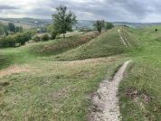
Hod Hill was an Iron-Age Hillfort and later the site of a Roman auxiliary fort. Situated just SE of Hambledon Hill, this rectangular fort was defended by a double bank and ditch on all sides bar the W, where the steep descent to the river Stour made only a single line of defences necessary. Entrances are at the NE and SW corners. It probably begun in the 5th century BC (radiocarbon date of c460BC), and the interior was dotted with hundreds of round hut depressions and storage pits following street lines, many of which can still be seen in the SE corner. The numerous buildings prove the fort was densely populated, and it remained so until it was taken by Vespasian and legio II sometime after 43AD. The Roman attack seems to have been directed upon the SE entrance, where a concentration of ballista bolts have been found around a large hut in this corner of the fort, which was itself surrounded by a rectangular palisade; piles of slingstones were found by its doors. The Romans built a fort in the NW corner of the hillfort at the highest point on the hill. This 4.4ha structure used the original defences on the N and W, with 2 main gates in the centre of new earthworks erected on the S and E sides. Built to take advantage of the views it commanded, and its access to the river, for which a small gate was made in the W Iron Age rampart, this fort housed about 600 legioaries and a force of 250 cavalry, and was occupied until its abandonment in 51AD.
Dunum – ‘The Hillfort’ Barry Cunliffe describes the pre-Roman hillfort at Hod Hill as a ‘late Iron-Age nucleated settlement’, the occupation area within the fortifications was about 52 acres (c.21 hectares), which is comparable in size to a standard Roman legionary fortress. The remains of many circular huts, some with small annexes, have been discovered in the south-east corner of the site. It would appear that although not all of the huts were occupied at the same time, the population started seriously to expand shortly after Julius Caesar’s visit to Britain c.50 BC . By the time Vespasian and Legio II Augusta arrived here, probably during the summer of AD 44, almost the entire area within the defences was inhabited.
Hod Hill fort
The Hod Hill fort is only mentioned in Geography of Ptolemy; the complete section is worth quoting:
Toward the west and south of these [the Belgae] are the Durotriges whose town is Dunium¹ 18*00 52°40. Next to these, but more to the west, are the Dumnoni, …” (Claudius Ptolemaeus Geographia II.ii)
- The Latin name Dunium is a simple Romanisation of the Welsh/Gaelic word Dunum or Dunon, which means simply ‘hillfort, stronghold’.
The Coming of Rome
A hastily organised attempt at multivallation was undertaken at Hod Hill in the time immediately prior to the Roman advance through the area in AD 43/44, but construction was apparently halted unfinished, probably in the face of Vespasian’s task force. This work may be seen on the above plan as a number of pits and trenches within the defences, on the north, south and eastern sides of the hillfort.
A large number of iron ballista-bolts were found concentrated within a remarkably small space in the south-east corner of the fort during archaeological excavations at the site between 1951 and 1958. Further investigation proved that the area had been occupied by a single large round-house building, more luxuriously appointed than the rest of the huts within the hillfort interior. A large ornate spear head was found inside this large hut, lying in detritus close to the doorway. It would appear that the chieftain’s house, easily identifiable by the Romans due to its size, was the target of a barrage of ballista bolts, probably from a number of such weapons, during which hail of fire the resident Durotrigian lord was killed, apparently before even taking up his spear. This display of devastating firepower would seem to have led to the rapid surrender of the dispirited natives, as no other signs of battle dateable to the period were found.
Map References for Hod Hill – Stourpaine, Dorset
NGRef: ST857106 OSMap: LR194
Sites near Hod Hill (Hillfort)
- Hod Hill (Dunum) Roman Fort (0 km)
Claudian Auxiliary Fort (AD 43–54) - Hambledon Hill (2 km)
Iron Age Hillfort and Neolithic Causewayed Enclosure - Iwerne Villa (3 km)
Villa - Farnham Villa (11 km)
Pottery and Villa - Vindocladia (Shapwick) (12 km)
Minor Settlement - Shapwick (Vindocladia Burgus) Roman Fort (12 km)
Claudian Auxiliary Fort (AD 43–54) - Badbury Rings (13 km)
Iron Age Hillfort - Dewlish Villa (16 km)
Villa - Ackling Dyke (17 km)
Roman Road - Lake Farm Roman Vexillation Fort (18 km)
Vexillation Fort


