The Geography of Ptolemy
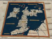
Table of Contents
- Roman Britain Version of Ptolemy’s Map
- Claudius Ptolemaeus – Geography – Hibernia Island of Britannia – Book II, Chapter 1
- Claudius Ptolemaeus – Geography – The Coastline of Mainland Britain Book II, Chapter 2 Part One
- Part Two – The Tribes and Cities of Mainland Britain
- Novantae
- Selgovae
- Damnoni
- Otalini
- Damnoni
- Venicones
- Taezali
- Brigantes
- Parisi
- Brigantes & Ordovices
- Cornavi
- Coritani
- Catuvellauni
- Iceni
- Trinovantes
- Demetae
- Silures
- Dobuni
- Atrebati
- Canti
- Regni
- Belgae
- Durotriges
- Dumnoni
- Part Three – The Remaining British Islands
Claudius Ptolemaeus was a Roman citizen of Macedonian descent (Rivet & Smith 1979, p.103), living and working in Alexandria, Egypt Claudius Ptolemaeus was a celebrated geographer and astrologer who lived between the reigns of Hadrian and Antonine in the second century A.D. He wrote all his scientific works in Greek but, his work, like so many ancient others (especially those in the Library at Alexandria), was lost for over a thousand years to Western scholarship. It was not until the 15th century that his work was rediscovered and translated into Latin, the commonly used language of western scholars at the time.
I know that I am mortal and the creature of a day: but when I search out the massed wheeling circles of the stars, my feet no longer touch the earth, but, side by side with Zeus himself, I take my fill of ambrosia, the food of the gods.
Ptolemy
He published several books on astronomy, including The Almagest which gave the positions of 1022 fixed stars by latitude and longitude, his discovery of the precession of the equinoxes, and also expounded an Earth-centred view on the workings of the universe based on epicycles – the Ptolemaic System – which was to remain unchallenged until the Polish astronomer Nicolaus Copernicus published his theory on a Sun-centred universe, the now-familiar Solar System, in 1543AD.

His most remarkable publication, however, was perhaps his Geography, a work of seven volumes, which became the standard textbook on the subject until the 15th century. In the opening chapters of the second book of the Geography, we find information appertaining to the British Isles:
- Chapter 1 is entitled Hibernia island of Britannia, and deals primarily with Ireland (Northern Ireland and Eire), including the islands of the Inner Hebrides, the Isle of Man, and curiously, Anglesey.
- Chapter 2 is entitled Albion island of Britannia, and deals with mainland Britain (England, Wales and Scotland), giving lists of the prominent coastal landmarks, river mouths and estuaries, as well as the names of the British tribes and their principal towns.
Roman Britain Version of Ptolemy’s Map
You can plot the coordinates in Ptolemy’s description of the British coastline to produce the following map.

When the are plotted, an obvious error becomes readily apparent: everything north of the Solway Firth (Ituna Aestuarium) on the western side and the mouth of the River Wear (Vedra Fluvius) on the eastern side appear to have been rotated clockwise by 90°, so all directions north of Hadrian’s Wall should be adjusted accordingly. However, there are alternative interpretations of which one is that the map is an expanded view of Scotland south of the Highlands.
The following text includes some degree of additional formatting, in an attempt to improve clarity. Some passages have been broken up to display in a tabular format. The additions [highlighted and enclosed in square brackets] are not original nor the question marks ?, which are used to indicate those names where more doubt than normal exists. The names of the British Tribes have been rendered in bold type and some passages have been displayed as headings
In addition, the following Latin¹ abbreviations have been adopted throughout the translated text:
- Aest. = Aestuarium = Estuary or tidal river-mouth.
- Fl. = Fluvius, Flumen = River.
- Ost. = Ostium = River-mouth.
- Pen. = Peninsula = A narrow strip of land projecting into the sea. The literal Latin meaning is ‘almost an island’.
- Prom. = Promonturium = Promontory or Headland. A high point of land or rocky coast which juts out into the sea.
- Sin. = Sinus = Bay. A wide indentation of the shoreline, especially between two peninsulas or promontories.
- I. = Insula = Island (used on diagram above).
- I know Ptolemy wrote in Greek, but Latin is much easier for most people to understand.
Claudius Ptolemaeus – Geography – Hibernia Island of Britannia – Book II, Chapter 1
[… Ptolemy’s description of the Irish coastline, rivers and towns has been omitted from here. …]
Above Hibernia are the Ebuda Insulae [?Hebrides Islands] five in number, the largest of which toward the west is called
| Ebuda | 15*00 | 62°00 | [?= Islay?] |
| next to this toward the east likewise is | |||
| Ebuda Insula | 15*40 | 62°00 | [?= Jura?] |
| then ?Rhicina | 17*00 | 62°00 | [?= Isle of Arran?] |
| then Malaeus | 17*30 | 62°30 | [= Malaius = Island of Mull] |
| then Epidium | 18*30 | 62°00 | [= Epidium Prom. = Kintyre, Strathclyde] |
Toward the east of Hibernia are these Islands
| Monaoeda Insula | 17*40 | 61°30 | [= Manavia Insula = Isle of Man] |
| Mona Insula | 15*00 | 57°40 | [= Mona Insula = Anglesey] |
| ?Adru which is barren | 15*00 | 59°30 | [unknown] |
| ?Limnu which is barren | 15*00 | 59°00 | [unknown] |
[end of chapter one]
Claudius Ptolemaeus – Geography – The Coastline of Mainland Britain Book II, Chapter 2 Part One
A description of the northern coast, above which is the Oceanus Duecaledonius
| Novantarum Pen. | [== Rhinns of Galloway] | ||
| and Prom. of the same name | 21*00 | 61°40 | [= Novantarum Prom. = Mull of Galloway] |
| Rerigonius Sin. | 20*30 | 60°50 | [== Loch Ryan, Dumfries & Galloway] |
| Vindogara Sin. | 21*20 | 60°30 | [== Irvine Bay, Strathclyde] |
| Clota Aest. | 22*15 | 59°20 | [== Firth of Clyde] |
| ?Lemannonius Sin. | 24*00 | 60°00 | [?= Loch Fyne?] |
| Epidium Prom. | 23*00 | 60°40 | [== Mull of Kintyre] |
| ost. ? Longus Fl. | 24*30 | 60°40 | [?= Firth of Lorn?] |
| ost. ? Itis Fl. | 27*00 | 60°40 | [unknown] |
| ? Volas Sin. | 29*00 | 60°30 | [unknown] |
| ost. ? Navarus Fl. | 30*00 | 60°30 | [unknown] |
| Tarvedum sive Orcas Prom. | 31*20 | 60°15 | [== Dunnet Head, Scottish Highlands] |
Description of the west1 side which borders on the Hibernian Ocean and the Vergionius Ocean
| Novantarum Prom. | 21*00 | 61°40 | [== Mull of Galloway, Dumfries & Galloway] |
| ost. ? Abravannus Fl. | 19*20 | 61°00 | [?= Water of Luce, Dumfries & Galloway?] |
| ? Iena Aest. | 19*00 | 60°30 | [?= River Cree, Dumfries & Galloway?] |
| ost. Devas Fl. | 18*00 | 60°00 | [== River Dee, Dumfries & Galloway] |
| ost. Novius Fl. | 18*20 | 59°30 | [== River Nith, Dumfries & Galloway] |
| Ituna Aest. | 18*30 | 58°45 | [== Solway Firth] |
| Moricambe Aest. | 17*30 | 58°20 | [== Morcambe Bay] |
| ?Portus Setantiorum | 17*20 | 57°45 | [?= nr. Fleetwood, Lancashire?] |
| Belisama Aest. | 17*30 | 57°20 | [== River Ribble, Lancashire] |
| Seteia Aest. | 17*00 | 57°00 | [== River Mersey, Merseyside] |
| Caeanganorum Prom. | 15*00 | 57°002 | [?= Ceanganorum Prom. = Point of Ayr, Clwyd (Deceangi)? ?= Ganganorum Prom. = Lleyn Peninsula, Gwynedd (Gangani/Ordovices)?] |
| ost. Toesobis Fl. | 15*40 | 56°20 | [= Tisobis Fl. = Tremadog Bay, Gwynedd] |
| ost. Stuccia Fl. | 15*20 | 55°30 | [= Stuctia Fl. = Afon Ystwyth, Dyfed] |
| ost. ?Tuerobis Fl. | 15*00 | 55°00 | [unknown] |
| Octapitarum Prom. | 14*20 | 54°30 | [== St. David’s Head, Dyfed] |
| ost. ?Tobius Fl. | 15*30 | 54°30 | [unknown] |
| ost. ?Ratostabius Fl. | 16*30 | 54°30 | [unknown] |
| Sabrina Aest. | 17*20 | 54°30 | [== River Severn, Gloucestershire] |
| Uxella Aest. | 16*00 | 53°30 | [== River Axe, Somerset] |
| Herculis Prom. | 14*00 | 52°45 | [== Hartland Point, Devon] |
| Antivestaeum sive Bolerium Prom. | 11*30 | 52°30 | [== Land’s End, Cornwall] |
| Damnonium sive Ocrium Prom. | 12*00 | 51°30 | [== Lizard Point, Cornwall] |
Description of the south side below which is the Oceanus Britannicus
After the Ocrium Prom. is
| ost. Cenio Fl. | 14*003 | 51°45 | [unknown] |
| ost. Tamarus Fl. | 15*40 | 52°10 | [== River Tamar, Devon and Cornwall] |
| ost. Iscas Fl. | 17*40 | 52°20 | [== River Exe, Devon] |
| ost. ?Alaunus Fl. | 17*40 | 52°40 | [unknown] |
| ?Magnus Portus | 19*00 | 53°00 | [?= Magnvs Portvs = Bosham Harbour, nr. Chichester, Sussex] |
| ost. Trisantonis Fl. | 20*20 | 53°00 | [= Trisantona Fl. = River Arun, Sussex] |
| ?Novus Portus | 21*00 | 53°30 | [?= nr. Brighton and Hove, Sussex] |
| Cantium Prom. | 22*00 | 54°00 | [== South Foreland, Kent] |
A description of the eastern and the southern side next to which is the Oceanus Germanicus
After the Tarvedum Prom., or Orcades, by which it is known
| Virvedrum Prom. | 31*00 | 60°00 | [== Duncansby Head, Scottish Highlands] |
| Verubium Prom. | 30*30 | 59°40 | [== Noss Head, Scottish Highlands] |
| ost. Ila Fl. | 30*00 | 59°40 | [== River Helmsdale, Scottish Highlands] |
| a high shore | 29*00 | 59°40 | [?= Foothills of Beinn Dhorain, Scottish Highlands] |
| Varar Aest. | 28*004 | 59°40 | [== Beauly Firth, Scottish Highlands] |
| ost. Loxa Fl. | 27*30 | 59°40 | [== River Lossie, Grampian] |
| Tuesis Aest. | 27*00 | 59°00 | [== River Spey, Grampian] |
| ost. Caelis Fl. | 27*00 | 58°45 | [== River Deveron, Grampian] |
| Taezalon Prom. | 27*30 | 58°30 | [= Taexalorum Prom. = Kinnaird’s Head, Grampian] |
| ost. Deva Fl. | 26*00 | 58°30 | [== River Dee, Grampian] |
| ost. Tina Fl. | 24*00 | 58°30 | [== River Eden, Fife] |
| Boderia Aest. | 22*30 | 59°00 | [= Bodotria Aest. = Firth of Forth] |
| ost. Alaunus Fl. | 21*20 | 58°30 | [== River Aln, Northumberland] |
| ost. Vedra Fl. | 20*10 | 58°30 | [== River Wear, Tyne & Wear] |
| Dunum Sin. | 20*15 | 57°30 | [== Tees bay, Cleveland] |
| ? Gabrantuicorum Sin. with many harbors | 21*00 | 57°00 | [?= Bridlington Bay?] |
| ? Ocelus Prom. | 21*15 | 56°40 | [?= Spurn Head, Humberside?] |
| ost. Abi Fl. | 21*00 | 56°30 | [= Abus Fl. = River Humber, Humberside] |
| Metaris Aest. | 20*30 | 55°40 | [== The Wash] |
| ost. Gariennus Fl. | 20*50 | 55°40 | [= Gariannus Fl. = River Yare, Norfolk] |
| a Promontory | 21*15 | 55°05 | [unknown] |
| ost. ? Sidumanis Fl. | 20*10 | 55°00 | [unknown] |
| Tamesa Aest. | 20*30 | 54°30 | [= Tamesis Aest. = Thames Estuary, Greater London] |
| Next to this the Cantium Prom. | 22*00 | 54°00 | [== South Foreland, Kent] |
Part Two – The Tribes and Cities of Mainland Britain
Novantae
The Novantae dwell on the side toward the north below the peninsula of this name, among whom are the following towns:
| ? Locopibia | 19*00 | 60°20 | [unknown] |
| ? Rerigonium | 20*10 | 60°40 | [unknown] |
Selgovae
Below are the Selgovae, among whom are the following towns:
| ? Carbantorigum | 19*00 | 59°30 | [unknown] |
| ? Uxellum | 18*30 | 59°20 | [unknown] |
| ? Corda | 20*00 | 59°40 | [unknown] |
| Trimontium | 19*00 | 59°00 | [= TRIMONTIVM = Newstead, Borders] |
Damnoni
From these toward the east, but more northerly, are the Damnoni, among whom are the following towns:
| ? Colanica | 20*45 | 59°10 | [?= COLANIA = Kirkintilloch, Dunbartonshire?] |
| ? Vindogara | 21*20 | 60°00 | [unknown] |
| ? Coria | 21*30 | 59°20 | [unknown] |
| ? Alauna | 22*45 | 59°50 | [unknown] |
| ? Lindum | 23*00 | 59°30 | [unknown] |
| ? Victoria | 23*30 | 59°00 | [unknown] |
Otalini
Further south are the Otalini5, among whom are the following towns:
| ?Coria | 2010 | 59°00 | [?= CORSTOPITVM = Corbridge, Northumberland?] |
| ?Alauna | 2300 | 58°40 | [?= ALAVNA = Learchild, Northumberland?] |
| Bremenium | 21*00 | 58°45 | [= BREMENIVM = High Rochester, Northumberland] |
Damnoni
Next to the Damnoni, but more toward the east near the Epidium Prom. are the Epidi and next to these the Cerones; then the Carnonacae, and the Caereni but more toward the east; and in the extreme east dwell the Cornavi; from the Lemannonis Sin. as far as the Varar Aest. are the Caledoni, and above these is the Caledonian forest, from which toward the east are the Decantae, and next to these the Lugi extending to the Cornavi boundary, and above the Lugi are the Smertae; below Caledonia are the Vacomagi, among whom are the following towns:
| ?Bannatia | 2400 | 59°30 | [unknown] |
| ?Tamia | 2500 | 59°20 | [unknown] |
| Alata Castra | 2715 | 59°20 | [unknown] |
| ?Tuesis | 2645 | 59°10 | [unknown] |
Venicones
Below these toward the west are the Venicones, whose town is
| ?Orrea | 2400 | 58°45 | [?= Horrea Classis = Carpow, Fife?] |
Taezali
More toward the east are the Taezali and the town
| ?Devana | 2600 | 59°00 | [?= Devana = Aberdeen, Grampian?] |
Brigantes
Below the Selgovae and Otalini are the Brigantes extending to both seas, among whom are the following towns:
| Epiacum | 1830 | 58°30 | [= Epiacvm = Whitley Castle, Northumberland] |
| Vinovium | 1745 | 58°00 | [= Vinovivm = Binchester, Durham] |
| Caturactonium | 2000 | 58°00 | [= Cataractonivm = Catterick, North Yorkshire] |
| ?Calatum | 1900 | 57°45 | [?= Calacvm = Burrow in Lonsdale, Lancashire?] |
| Isurium | 2000 | 57°40 | [= Isvrivm = Aldborough, North Yorkshire] |
| ?Rigodunum | 1800 | 57°30 | [?= Rigodvnvm = Castleshaw, Greater Manchester?] |
| ?Olicana | 1900 | 57°30 | [?= Olenacvm = Elslack, Lancashire?] |
| Eboracum, Legio VI Victrix | 2000 | 57°20 | [= Ebvracvm = York, North Yorkshire] |
| ?Camulodunum | 1800 | 57°45 | [?= Cambodvnvm = Slack, South Yorkshire?] |
Parisi
Near which on the Opportunum Sin. are the Parisi and the town
| Petuaria | 2040 | 56°40 | [= Petvaria = Brough on Humber, Humberside] |
Brigantes & Ordovices
Below these are the Brigantes but some distance toward the west are the Ordovices, among whom are the towns:
| Mediolanum | 1645 | 56°40 | [= Mediolanvm = Whitchurch, Shropshire] |
| ?Brannogenium | 1645 | 56°15 | [?= Bravonivm = Leintwardine, Hereford & Worcester?] |
Cornavi
From these toward the east are the Cornavi, among whom are the towns:
| Deva, Legio XX Victrix | 1730 | 56°45 | [= Deva = Chester, Cheshire] |
| Viroconium | 1645 | 55°45 | [= Viroconivm = Wroxeter, Shropshire] |
Coritani
Next to these are the Coritani, among whom are the towns:
| Lindum | 1840 | 56°30 | [= Lindvm = Lincoln, Lincolnshire] |
| Ratae | 1800 | 55°30 | [= Ratae = Leicester, Leicestershire] |
Catuvellauni
Next are the Catuvellauni, among whom are the towns:
| ?Salinae | 2045 | 55°50 | [unknown] |
| Urolanium | 1920 | 55°30 | [= Vervlamivm = St. Alban’s, Hertfordshire] |
Iceni
Next to these are the Iceni, whose town is called:
| Venta | 2030 | 55°20 | [= Venta = Caistor St. Edmund, Norfolk] |
Trinovantes
Farther eastward and near the Tamesa Aestuarium are the Trinovantes and the town
| Camulodunum | 2100 | 55°00 | [= Camvlodvnvm = Colchester, Essex] |
Demetae
Below the peoples we have mentioned, but more toward the west are the Demetae, whose towns are:
| ?Luentinum | 1545 | 55°10 | [?= Lventinvm = Pumsaint, Dyfed] |
| Maridunum | 1530 | 54°40 | [= Moridvnvm = Carmarthen, Dyfed] |
Silures
More toward the east are the Silures whose town is
| ?Bullaeum | 1650 | 55°00 | [?= Bvrrivm = Usk, Gwent] |
Dobuni
Next to these are the Dobuni, and their town
| Corinium | 1800 | 54°10 | [= Corinivm = Cirencester, Gloucestershire] |
Atrebati
then the Atrebati and their town
| Caleva | 1900 | 54°15 | [= Calleva = Silchester, Hampshire] |
Canti
Next to these, but farther eastward, are the Canti among whom are the towns:
| Londinium | 2000 | 54°00 | [= Londinivm = London, Greater London] |
| ?Daruernum | 2100 | 54°00 | [= Dvrovernvm = Canterbury, Kent] |
| Rutupie | 2145 | 54°00 | [= Rvtvpiae = Richborough, Kent] |
Regni
Below the Atrebati and the Canti are the Regni and the town:
| Noeomagus | 1945 | 53°05 | [= Noviomagvs = Chichester, Sussex] |
Belgae
Below the Dobuni are the Belgae and the towns:
| ?Iscalis | 1600 | 53°40 | [?= Iscalis = nr. Bawdrip, Somerset?] |
| Aquae Calidae | 1720 | 53°40 | [= Aqvae Svlis = Bath, Avon] |
| Venta | 1840 | 53°00 | [= Venta = Winchester, Hampshire] |
Durotriges
Toward the west and south of these are the Durotriges whose town is:
| ?Dunium | 1800 | 52°40 | [?= Dvnvm = Hod Hill, Dorset?] |
Dumnoni
Next to these, but more to the west, are the Dumnoni, whose towns are:
| ?Voliba | 1445 | 52°00 | [unknown] |
| ?Uxella | 1500 | 52°45 | [?= Vxelis = Launceston, Cornwall?] |
| ?Tamara | 1500 | 52°15 | [?= Tamaris = Plymouth, Devon?] |
| Isca, where is located Legio II Augusta | 17*30 | 52°45 | [= Isca = Exeter, Devon] |
Part Three – The Remaining British Islands
The islands which are near Albion Insula and the Orcades Prom. are:
| Scetis island | 32*40 | 60°45 | [= Scitis = Skye] |
| ? Dumna island | 30*00 | 61°20 | [?= Outer Hebrides (North Uist, South Uist & Isle of Lewis] |
Above these islands are the Orcades, about thirty in number:
| the middle of which is in | 30*00 | 61°40 | [?Orcades = Orkneys (possibly including Shetlands] |
Far above these is the island ?Thule. [?= Thule / Ultima Thule ?= Shetland Islands ?= Iceland ?= Norway == A mythical northernmost inhabitable island.]
| The part of this which extends much toward the west is in | 29*00 | 63°00 |
| that which is farthest eastward is | 31*40 | 63°00 |
| that which is farthest northward is | 30*20 | 63°15 |
| that which is farthest southward is | 30*20 | 62°40 |
| the middle is in | 30*20 | 63°00 |
Eastward from the Trinovantes region there are two islands:
| ?Toliapis | 23*00 | 54°20 | [?= TANATVS Isle of Thanet, Kent?] |
| ?Counus island | 24*00 | 54°30 | [unknown] |
Below Magnus Portus is the island Vectis:
| the middle of which is in | 19*20 | 52°20 | [= VECTIS = Isle of Wight, Hampshire] |
[end of chapter two]
Textual Amendations
| 1 | The 1932 edition has east. |
| 2 | The 1932 edition has 56°00. |
| 3 | The 1932 edition has 14*51. |
| 4 | The 1932 edition has 27*00. |
| 5 | The 1932 edition has Otadini. |
Bibliographical Links
- The Geography of Claudius Ptolemaeus, trans. by E.L. Stevenson (Dover, New York, 1991);
- Place Names of Roman Britain by A.L.F. Rivet & Colin Smith (Batsford, London, 1979);
- Historical Map and Guide: Roman Britain by the OS (4th Ed., 1990);


