London (Londinium) Roman Settlement
Claudian Auxiliary Fort (AD 43–54), Legionary Fort, Palace and Triumphal Arches
Londinium, modern day London was the capital of Roman Britain during most of the period of Roman rule. It was originally a settlement established on the current site of the City of London around AD 47–50. It sat at a key crossing point over the River Thames which turned the city into a road nexus and major port, serving as a major commercial centre in Roman Britain until its abandonment during the 5th century.
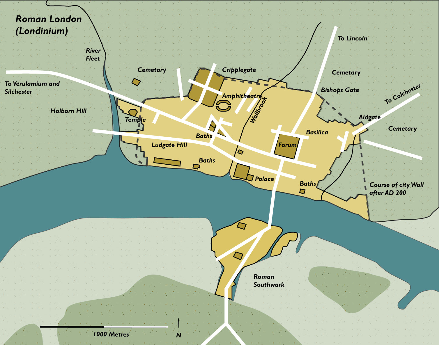
Following the foundation of the town in the mid-1st century, early Londinium occupied the relatively small area of 1.4 km2, roughly half the area of the modern City of London and equivalent to the size of present-day Hyde Park. In the year 60 or 61, the rebellion of the Iceni under Boudica compelled the Roman forces to abandon the settlement, which was then razed. Following the defeat of Boudica by the Roman governor Gaius Suetonius Paulinus a military installation was established and the city was rebuilt. It had probably largely recovered within about a decade. During the later decades of the 1st century, Londinium expanded rapidly, becoming Britannia’s largest city, and it was provided with large public buildings such as a forum and amphitheatre. By the turn of the century, Londinium had grown to perhaps 30,000 or 60,000 people, almost certainly replacing Camulodunum (Colchester) as the provincial capital, and by the mid-2nd century Londinium was at its height. Its forum-basilica was one of the largest structures north of the Alps when the Emperor Hadrian visited Londinium in 122. Excavations have discovered evidence of a major fire that destroyed much of the city shortly thereafter, but the city was again rebuilt. By the second half of the 2nd century, Londinium appears to have shrunk in both size and population.
Although Londinium remained important for the rest of the Roman period, no further expansion resulted. Londinium supported a smaller but stable settlement population as archaeologists have found that much of the city after this date was covered in dark earth—the by-product of urban household waste, manure, ceramic tile, and non-farm debris of settlement occupation, which accumulated relatively undisturbed for centuries. Some time between 190 and 225, the Romans built a defensive wall around the landward side of the city. The London Wall survived for another 1,600 years and broadly defined the perimeter of the old City of London.
Classical References to Londinium
The standard second century geographical reference work by Claudius Ptolemaeus, mentions both the town of Londinium (vide infra) and the Tamesa Aestuarium (the Thames Estuary), on the upper reaches of which the settlement was located.
Next to these,¹ but farther eastward, are the Canti² among whom are the towns: Londinium 20*00 54? Darvernum 21*00 54? Rutupie 21*45 54?.³
- The Atrebates tribe of Hampshire and Berkshire.
- The Cantiaci tribe inhabited Cantium (Kent). This is curious, for London is generally thought to have been located in the territories of the Catuvellauni.
- These three towns are, respectively; London, Canterbury, and Richborough, the latter two being in Kent.
The work which best describes the location of Londinium is the Antonine Itinerary, an official imperial document of the late-second century which listed many of the major road routes of the Roman empire, fifteen of them in Britain, over half of which mention Londinium.
- Antonine Itinerary Iter II
- Route: From Hadrian’s Wall to Richborough (Rutupiae)
- Location in Itinerary: 12 miles from Sulloniacis (Brockley Hill, Greater London) 10 miles from Noviomago (Crayford, Greater London)
- Antonine Itinerary Iter III
- Route: From London to Dover (Kent)
- Location:: 27 miles from Durobrivis (Rochester, Kent)
- Antonine Itinerary Iter IV
- Route: From London to Lympne (Kent)
- Location: 27 miles from Durobrivis (Rochester, Kent)
- Antonine Itinerary Iter V
- Route: From London to Carlisle (Luguvalium) (Cumbria) on the Wall
- Location:: 28 miles from Caesaromago (Chelmsford, Essex)
- Antonine Itinerary Iter Vi
- Route: From London to Lincoln (Colonia Lindum)
- Location:: 21 miles from Verolami (St. Alban’s, Hertfordshire)
- Antonine Itinerary Iter VII
- Route: From Chichester (West Sussex) to London
- Location:: 22 miles from Pontibus (Staines, Surrey)
- Antonine Itinerary Iter VIII
- Antonine Itinerary Iter IX
- Route: From Caistor St. Edmund (Norfolk) to London
- Location:: 15 miles from Durolito(Romford, Greater London)
Part XI – The Count of the Sacred Bounties
Under the control of the illustrious count of the sacred bounties: … The accountant of the general tax of the Britains. Provosts of the storehouses: … In the Britains: The provost of the storehouses at London. … Procurators of the weaving-houses: … The procurator of the weaving-house at Winchester in Britain. …
Above quote from the The Notitia Dignitatum of the 4th/5th century AD
London also appears in the Ravenna Cosmology of the seventh century as Londinium Augusti (R&C#97), which appears between the entries for Verulamium (St. Albans, Hertfordshire) and Caesaromagus ( Chelmsford, Essex).
Epigraphic Evidence from London
RIB 1 - Dedication to Mithras - London (Londinium)
… (give) life to men who wander.
The inscription in rough lettering may be a later addition. As in many inscriptions of the later centuries, the letter b is used instead of v for vagis vitam.The marble is probably Italian (Professor B. Ashmole to R.P.W., 3 July 1956).
There are thirty-nine Latin inscriptions on stone recorded in the R.I.B. for London, about a fifth of which are fragmentary or otherwise illegible. A selection of the more interesting inscriptions are presented on this page, under several categories; the Roman military presence in London, the gods and religious institutions, also military and civilian tombstones.
The Claudian Encampment
A length of an early camp ditch was found at Fenchurch Street (Britannia 18 (1987) p.333; Brit. 20 (1989) pp.305-6) and Duke’s Place (Brit. 4 (1973) p.306), evidence suggests that the ditch was filled-in soon after it was dug. There is room on the east hill for a camp of no more than c.75 acres (30.5ha), which is slightly more than half the size of the enclosure at Richborough (Rutupiae). Because of this, it has been suggested that another large camp was erected near the Westminster Crossing, probably somewhere near Hyde Park.
The Roman Military
The only type of Roman military unit attested on stone at London are those of the Legions, even though it is generally thought that an auxiliary unit was stationed here nothing ‘concrete’ has been turned up. Three of Britain’s legions are represented at London, The The Second Augustan Legion (Legio Secundae Augusta) is attested on an altar dedicated to the god Mithras and on two tombstones of former soldiers from the legion (respectively, RIB 3, 17 & 19), one of them dated to the first quarter of the third century, the Legio Vicesimae Valeria Victrix (The Twentieth Legion, Valiant and Victorious) is represented by another two tombstones (RIB 13 & 18), and the Legio Sextae Victrix – The Sixth Victorious Legion is mentioned only on a single funerary inscription (RIB 11). All of these Latin texts are detailed and translated separately below.
Legio Secundae Augusta – The Second Augustan Legion
RIB 17 - Funerary inscription for Vivius Marcianus - London (Londinium)
To the spirits of the departed and to Vivius Marcianus, centurion of the Second Legion Augusta, Januaria Martina his most devoted wife set up this memorial.
VIVIO MARCI
ANO 𐆛 ❦ LEG II
AVG IANVARIA
MARTINA CONIVNX
PIENTISSIMA POSV
IT MEMORIAM
5. For the date of this text to a married soldier see note to RIB 11. Addenda from RIB+add. (1995): Marcianus was probably the princeps praetorii, the centurion who headed the governor’s office staff.

RIB 19 - Funerary inscription for Celsus - London (Londinium)
To the spirits of the departed: […]r Celsus, son of Lucius, of the Claudian voting-tribe, [from …], speculator of the Second Legion Augusta An[to]nius Dardanus Cu[rsor], [Val]erius Pudens, and […]s Probus, speculatores of the legion (set this up).
[4]R L F C[...] CELSV[...]
[4 ]PEC LEG [... ]VG AṆ
[...]N DARDANVS CV[...]
[...]ERIVS PVDENS
[4]S PROBVS SP[...]C L[...]
2. For nomina ending in ]r cf. CIL v 618 (Meter), CIL vi 3884 (Maeter), CIL vi 215 (Locer); cf. Schulze, Zur Geschichte lateinischer Eigennamen (1933) p. 297. 6. Below this line came the petals of a floral device. A speculator was a legionary seconded to the governor’s staff like the beneficiarius consularis, but of higher rank, who served as a secretary or special emissary. Addenda from RIB+add. (1995): The presence of speculatores is evidence that London was already the provincial capital: Mann, Antiq. 35 140 (1961), 318; Mann and Jarrett, JRS 57 (1967), 62-3.

Legio Sextae Victrix – The Sixth Victorious Legion
RIB 11 - Funerary inscription for Flavius Agricola - London (Londinium)
To the spirits of the departed: Flavius Agricola, soldier of the Sixth Legion Victrix, lived 42 years, 10 days Albia Faustina had this made for her peerless husband.
FL AGRICOLA MIL
LEG VI VICT V AN
XLII D X ALBIA
FAVSTINA CONIVGI
INCONPARABILI
F C
The stone mentions a wife married to a soldier during his term of service. As this practice was first allowed by Septimius Severus (Herodian iii 8, 5), this text must be later in Britain than A.D. 197.

Legio Vicesimae Valeria Victrix – The Twentieth Legion, Valiant and Victorius
RIB 13 - Funerary inscription for Julius Valens - London (Londinium)
To the spirits of the departed Julius Valens, soldier of the Twentieth Legion Valeria Victrix, aged 40, lies here, his heir Flavius Attius having the matter in charge.
IVL VALENS
MIL LEG XX V V
AN XL H S E C A FLAVIO
ATTIO HER
The Twentieth Legion was stationed at Chester from Flavian times; this text dates probably from the late first century.
RIB 18 - Fragmentary funerary inscription - London (Londinium)
…]urni[n … of the Twentieth Legion Valeria Victrix Gaius Acilius M[… set this up.
VRNI[ ...]
LEG XX [ ]
G ACI[...]
M[...]
No commentary.

The Gods of Roman London
RIB 3002 - Altar to Jupiter Optimus Maximus (?) - London (Londinium)
For Jupiter Best and Greatest, Aquilinus freedman of the Emperor, and Mercator and Audax and Graecus, restored (this) [temple] collapsed from age.
[...] VẸTVS
[.]ATE COṆḶABSVM
ẠQVILINVS AVG ❦
LIB ET MERCATOR
ET AVDAX ET GRAEC ❦
RESTITVER
1. […] M. The enlargement of this letter, and the space to left and right, indicate that it concludes an abbreviated dedication. Altars dedicated to Jupiter are so frequent that I O M is the likeliest restoration, even if it implies that his temple in the provincial ‘capital’ had fallen down. To the left of M there is a diagonal chisel cut which, while too shallow to be part of the second stroke of the letter A, might be the tail of a centrally placed leaf stop; this would imply that there were only two letters in the first surviving line. In that case either [DEO] | [I(NVICTO)] M(ITHRAE) or [MATRI] | [D(EVM)] M(AGNAE) would be possible. 3. [vetust]ate conlabsum. See note to RIB 3001, line 10. 4–5. Aug(usti) lib(ertus). G is badly damaged, and seems to be followed by the remains of a leaf-stop like that in 6. L has no second stroke (contrast L in AQVILINVS). Imperial freedmen in the provinces administered imperial estates or occupied senior posts in the Procurator’s office; compare Aurelius Marcio, freedman procurator of Britain (CIL iii 348 = ILS 1477 (Phrygia) with A.R. Birley 2005, 328–9), and the imperial freedmen attested at York (RIB 643), near Bath (RIB 179) and perhaps at Lincoln (RIB 3173) and in the Vindolanda Tablets (Tab. Vindol. III, app. 352 back 1). Mercator, Audax and Graecus, whose status is not specified, may have been imperial slaves, junior colleagues of Aquilinus, for which compare Vegetus Montani imperatoris Aug(usti) ser(vus) in London (Britannia 34 (2003), 373, No. 22) and the Caesariani in Tab. Vindol. III, 645.

RIB 2 - Dedication to the Mother Goddesses - London (Londinium)
To the Mother Goddesses the district restored (this shrine) at its own expense..
VICINIA DE SVO RES[...]
Haverfield points out that it might have come originally from abroad, but there seems to be no reason to doubt its Romano-British origin.vicinia: although CIL viii 14743 shows that Vicinia was a personal name, it seems better to interpret it as ‘district’, evidently without a qualifying adjective, on the analogy of CIL xiii 3652 (Genio viciniae).
RIB 5 - Dedication to the Divinity of the Emperor - London (Londinium)
To the Divinity of the Emperor the province of Britain (set this up).
PROV[...]
BRITA[...]
For the use of the formula Numen Caesaris Augusti in provincial worship as early as Augustus see CIL xii 4333 (ILS 112) Narbo. How the identity of the emperor concerned was indicated is not now evident; either a portrait-statue or some further text would have been needed. In literature Caesar Augustus means the reigning emperor. For its use to denote Claudius see CIL vi 5539 (ILS 1786) Rome, and to denote either Claudius or Nero see CIL vi 8943 (ILS 1838) Rome, CIL x 5056 (ILS 977) Atina.
The Temple of Mithras
RIB 3 - Dedication to Mithras - London (Londinium)
Ulpius Silvanus, emeritus of the Second Legion Augusta, paid his vow enlisted at Orange.
VS
SILVA
NVS
FAC
TVS
ARAV
SIONE
EMERI
TVS LEG
II AVG
VOTVM
SOLVIT
A emeritus was a time-expired soldier, equivalent to veteranus.Arausio: Colonia Iulia Secundanorum, founded by Julius Caesar with veterans of the Second Legion.factus: interpreted by Mommsen as ‘made a veteran’, but the usual word would be missus. It has also been taken to mean ‘initiated’ into some Mithraic grade, but, if this were so, the grade should be mentioned. miles factus with the consular date is used by vigiles (ILS 2163), and by legionary veterans (ILS 2300, 2301, Apulum, Dacia), of their original enrolment. The London inscription mentions Arausio with no other details. It seems best to regard the action here recorded as the original recruitment of Ulpius Silvanus, which may well have occurred at Arausio, the Second Legion colony. Addenda from RIB+add. (1995): Birley Review, 228, translates factus Arausione as ‘initiated at Orange’, noting that Legion II Augusta had no special tie with Arausio (its Second Legion was Legion II Gallica, cf. AE 1952, 44); but factus in this sense is unparalleled.

RIB 4 - Dedication to Mithras and the Invincible Sun - London (Londinium)
For the welfare of our August Emperors and most noble Caesar¹ to the god Mithras and the Invincible Sun² from the east to the west.
[...]
[...] INVICTO
[... .] AD [...]ENTEM
- I am inclined to assign a date between AD307 to AD310, biased towards the latter. During this time the Roman world was ruled by the tetrarchy of Galerius, Maxentius and Constantine, while their fourth colleague Maximian was replaced by Licinius in 308. In AD310 Galerius appointed a fifth Caesar to replace himself in the east, Maximinus Daia, who may be the ‘noble Caesar’ mentioned in this inscription. Galerius himself died in 311.
- Sol Invictus was a pseudonym of Mithras.
This marble comes ‘probably from the Greek Islands, and is similar to that from Thasos
The Temple of Isis
A temple to the great Egyptian goddess Isis was tantalizingly suggested by the discovery of an earthenware jug at Southwark on the opposite side of the Thames from the Londinium settlement, close to the line of the Watling Street through Cantium. This object was inscribed with the words LONDINI AD FANVM ISIDIS or “From London at the temple of Isis“, and has been dated to the latter half of the second century. It was not until the mid-1970’s that a Roman altarstone dedicated to the goddess was finally discovered (See RIB 3001 below).
RIB 3001 - Altar to the Divine House - London (Londinium)
M ▸ MARTIAN
NIVS ▸ PVLCH
ER ▸ V ▸ C ▸ LEG
AVGG ▸ PRO ▸
PR
The nomen Martianius is unique, but was ‘fabricated’ from the cognomen Martianus, probably the father’s cognomen, in the way typical of the Celtic provinces. The first governor of Britain to be described as v(ir) c(larissimus) is Alfenus Senecio, so the governorship of Martianius Pulcher should be dated to a joint-reign in the third century, but no later than c. 260, after which a senatorial legate would be most unlikely. The likely periods are 221–2, 235–8, and most of 238–60, in all of which his province would have been Britannia Superior. The temple has not been found, but it is also named on the Southwark jug, Londini ad fanum Isidis. 8–9. .[…]TIS.
Altarstone to Mars Camulos
In 2002 a Roman plaque was discovered London measuring 12 x 16 inches (c.30 x cm) which contains a complete Latin inscription dedicated to the god Martius Camulos. The plaque probably dates from between 50 and 150 AD and would have been placed prominently either on a building or in a shrine.
RIB 3014 - Dedication to the Divinities of the Emperors and Mars Camulus - Southwark
To the Divinities of the Emperors (and) to the god Mars Camulus. Tiberinius Celerianus, a citizen of the Bellovaci, moritix, of Londoners the first […].
DEO MARTI CA
MVLO ❦ TIBERINI
VS CELERIANVS
❦ C ❦ BELL ❦
❦ MORITIX ❦
LONDINIENSI
VM
1. num(inibus) Aug(ustorum). This dedication is often combined with one to a deity, a plurality of emperors being commonly indicated by AVG or AVGVSTORVM; but for AVGG see RIB 459, 918, 1596, 2042, and especially 627, NVM AVGG (dated 208). While AVGG might refer to the emperors living and dead, it is best taken to refer to two living emperors (Fishwick 1994). This usage is first found for Marcus Aurelius and his colleagues (in 161–9 and 177–80), a date much better suited to the quality of the lettering than the Severan period. 2–3. The god Mars Camulus is attested in Britain only by RIB 2166 (Bar Hill), and is otherwise connected with the Remi: see for example AE 1935, 64 (his temple at Reims), CIL xiii 8701 = AE 1980, 656 (another temple erected by cives Remi), and CIL vi 46 (Rome, a dedication by a civis Remus). 3–5. The dedicator is otherwise unknown, but his rare nomen is ‘fabricated’ from a cognomen (Tiberinus), like many in northern Gaul. The Bellovaci were a civitas somewhat to the west of the Remi, and the expansion of c(ivis) Bell(ovacus) is inevitable; compare CIL xiii 611 (Bordeaux), ob memoriam Vestini Onatedonis (filii) c(ivis) Bel(lovaci). 6. moritix. As moritex this term is found in CIL xiii 8164a = ILS 7522 (Cologne), a dedication by G(aius) Aurelius G(ai) l(ibertus) Verus negotiator Britannicianus moritex. It should perhaps be read in the lost RIB 678+add. (York), M(arcus) Verec(undius) Diogenes sevir col(oniae) Ebor(acensis) itemq(ue) morit(ix) cives Biturix Cubus, but this is not certain. The etymology of the word (‘seafarer’) from Celtic *mori-teg-|tig- is not in doubt, and either spelling would be acceptable: see Uhlich 2002, 420 s.v. moritex; and Delamarre 2003, 194. But the specific meaning is unknown. Moritex was evidently a term applied to Gauls engaged in seaborne trade between Britain and the Continent, but was it simply a loan-word equivalent to nauta (‘sailor’), navicularius (‘shipmaster’) or nauarchus (‘ship’s captain’), or was the moritex specifically an official, or at least a member of a trade association (collegium)? The last seems the likeliest possibility. 7–8. Londiniensium. Hitherto this word has occurred only as the adjective derived from Londinium (Rivet and Smith 1979, 396), and this is its first occurrence as a noun, ‘(of) Londoners’. The informality of the usage in –enses does not mean that London lacked formal status (see RIB 3006 with note): compare AE 1912, 250 (Ostia, a colonia), the epitaph of a fire-fighter who received a public funeral from the Ostienses; and CIL v 8972 = ILS 1459 (Aquileia, also a colonia), a public dedication to their patron by the Aquileienses. This Gallic citizen evidently called himself a ‘Londoner’ in the way that Verecundius Diogenes, cives Biturix Cubus, was also a sevir Augustalis of the colonia Eboracensis (RIB 678, York). 9–10. After PRIMVS there is a broken edge with trace of a triangular medial point and two unidentifiable serifs. In the middle of 10 there is sufficient trace of V and A (or M). Since the surviving text ends here, the question of whether moritix stood alone, or was qualified by Londiniensium and even by primus, must remain open. Moritex is unqualified in CIL xiii 8164a and RIB 678 (see above): too small a sample to be decisive, but suggesting that Celerianus was not ‘moritix of the Londoners’ (whatever that might mean), but rather a moritix who was the first ‘Londoner’ to […]. But what his achievement was can only be guessed: perhaps he introduced a new cult, rather like Aurelius Lunaris, sevir Augustalis of the coloniae of York and Lincoln, who brought his own altar with him from Britain to Bordeaux (JRS 11 (1921), 101–7 = AE 1922, 116); or perhaps he was the first to hold a new office, for which compare CIL iii 1132 = ILS 7142 (Apulum), primus IIIIvir m(unicipii) A(urelii) Apuli and later CIL iii 1083 = ILS 7143 (Apulum), primus annualis mun(icipii) Sept(imii) Apul(i); also IRT 412 (Lepcis), praef(ecto) publ(ice) creato cum primum civitas Romana adacta est.
Possible Apsidal Temple
Aside from the famous temple of Mithras and the suspected temples of Isis and Camulos Mars detailed above, a possible temple is thought to have lain beneath the south-west corner of the 2nd-century forum/basilica, and obviously predated these monumental public buildings. The building is rectangular, measuring about 60 ft. by 34 ft. (c.18.3 x 10.4), with a squarish apse at its northern end. The walls of the building were an almost-uniform 3 ft. thick throughout, including a dividing wall which bisected the building into two, a squat rectangular room to the south had an entrance in its east side, and a portal in the partition wall led through to a square room at the north end with a projecting apse. This building is thought to be an apsidal shrine to some unknown deity.
Civilian and Military Tombstones
Of the five inscriptions shown in below, RIB 16 is a scarcophagus, RIB 22 is a base of some sort, RIB 10 is undefined and the other two are tombstones.
To the spirits of the departed and to Sempronius Sempronianus, centurion of the … legion (who) lived 51 years and to his brothers Sempronius … and Sempronius Secundus his freedmen had this set up for their well-deserving patrons.
[...]NIO SEMPRO
[...]TVRIONI LEG
[6 ...]XIT ANNOS LI
[... ]VS SEMPRONIIS
[9] ET SECVNDO
[...]TI EIVS
[... ...]REN
[...]V[...]NT
No commentary.

RIB 9 - Funerary inscription for Aulus Alfidius Olussa - London (Londinium)
Aulus Alfidius Olussa, of the Pomptine voting-tribe, aged 70, born at Athens, lies here in accordance with his will his heir set (this) up.
OLVSSA EX TES
TAMENTO HER
POS ANNOR LXX
NA ATHENI
H S EST
5. An addition, but seems practically contemporary. 6. This formula is rare after the first century.

RIB 10 - Funerary inscription for Marcus Aurelius Eucarpus - London (Londinium)
To Marcus Aurelius Eucarpus, her most devoted son, (who) lived 15 years, 6 months, his mother, Aurelia Eucarpia, set (this) up.
AVR EVCARPO
FIL PIENTISSIMO
VIXIT ANN XV
M VI AVR EVC
ARPIA MA POSSVIT
The material is foreign, but the associated pottery and the ligatured letters suggest that it is not a modern import from Italy.
RIB 16 - Funerary inscription for Valerius Amandinus - London (Londinium)
To the memory of Valerius Amandinus Valerius Superventor and Valerius Marcellus made this for their father.
DINI VALERI SVPERVEN
TOR ET MARCELLVS PATRI FECER
No commentary.
RIB 21 - Funerary Inscription of Claudia Martina - London (Londinium)
To the spirits of the departed (and) to Claudia Martina, aged 19 Anencletus, slave of the province, (set this up) to his most devoted wife she lies here.
CL MARTI
NAE AN XIX
ANENCLE
TVS
PROVINC
CONIVGI
PIENTISSIMAE
H S E
The formula in l. 9 suggests a late-first-century date.
RIB 22 - Funerary inscription for Grata - London (Londinium)
To the spirits of the departed: Grata, daughter of Dagobitus, aged 40 Solinus had this erected to his dearest wife.
GRATA DAGO
BITI FIL AN XL
SOLINVS CON
IVGI KAR F C
No commentary.
RIB 3005 - Funerary inscription for Gaius Pomponius Valens - London (Londinium)
To the shades of the dead (and) of Gaius Pomponius Valens, son of Gaius, of (colonia) Victricensis, [beneficiarius] of a tribune of the Legion …
G ▸ POMPONI
G ▸ F ▸ VÍ¡ALENTÍ¡IS
VICTÍ¡RICEÍ¡NS[...]
[...] T[.]
1. Dis Manibus. The use of this formula unabbreviated suggests a Flavio-Trajanic date (conversely there is just one instance of DIS MANIB for the Sixth Legion, RIB 252), which is supported by the letter-forms; complex ligatures are also found on two legionary tombstones earlier than c. 86 at Chester (RIB 475 and 480). 4. Victricens[is]. Adjective of origin derived from the title of the colonia at Camulodunum (Colchester): see CIL xiv 3955 = ILS 2740 (near Nomentum), Cn. Munatius Aurelius Bassus, censitor civium Romanorum coloniae Victricensis quae est in Britannia Camaloduni; CIL iii 660, colo(ni)ae Vict(ric)ensium. It is also borne by a centurion buried in Dacia, [T]itio G(ai) f(ilio) [Vi]ctrice(ensi) [Ia]nuario (AE 1977, 713). 5. [b(ene)f(iciarii)] t[r]ib(uni) [leg(ionis) …]. The ligatures required by this reading are shown in the drawing. The restoration is attractive since men and officers of all three legions are found in London, probably as members of the governor’s staff; but note that in Britain BF TRIB, unlike BF COS, are otherwise found at legionary headquarters (RIB 532, 545).
The History of Roman London
The settlement of Londinium was established shortly after the Claudian invasion in the summer of 43AD. The first Roman building was an Auxiliary Fort, built on the north bank of the Thames to the east of the Walbrook on the instructions of the military governor Aulus Plautius. The fort was established to guard the northern end of a wooden bridge which had been rapidly built across the Thames between Southwark and the north bank, also to secure the western flank during the Roman push eastwards against the British capital at Camulodunum (Colchester, Essex).
A civilian settlement comprised of the soldiers dependents, assorted native tradesmen and foreign merchants soon developed to the east of the Walbrook outside the defences of the fort, which was itself demolished after only a short period of use, probably before the 50AD’s, as the Roman military campaigns were extended into the Midlands and Wales. Though unprotected, the settlement had become well established as an important provincial town by the time the Iceni and the Trinovantes tribes rose in revolt in the winter of 60/61AD and destroyed the colony at Colchester (Camulodunum), fifty miles from London. At the time, the governor Suetonius Paulinus was campaigning on the Isle of Anglesey, over two-hundred miles away.
London Razed During the Boudiccan Revolt
Suetonius, however, with wonderful resolution, marched amidst a hostile population to Londinium, which, though undistinguished by the name of a colony, was much frequented by a number of merchants and trading vessels.
Upon hearing of the uprising to his rear, the Roman legate immediately gathered together all the legionary and auxiliary forces as he could possibly spare from the Midlands and Wales, then marched south-east to counter the rebel force. Despite his swift response, he was unable to stop the ravaging horde from falling upon defenceless London. The revolting natives razed the entire town to the ground. All who did not flee were massacred, their severed heads thown into the Walbrook stream. Chaos reigned throughout the South-East. Suetonius was forced to retreat back along the Watling Street, surrendering also the thriving town of Verulamium to the rebels as he fled north-west into the Midlands. Here however, as the unruly revolutionaries were delighting in rapine and destruction, he was able to concentrate his forces and a short time afterwards engineered a crushing defeat on the combined British army outside Manduessedum (Mancetter, Warwickshire).
Following the revolt, the province of Britain was very nearly surrendered by Rome, but the emperor Nero was turned from this course of action by the arguments of his advisor and former tutor Seneca, who had invested a lot of money in Britain and would have suffered financially if Rome were not to retain the island. As a result of Seneca’s persuasive arguments, Julius Classicanus was appointed to the post of procurator of Britain. This was a non-military position whose main role was to restore economic order in the war-torn province. Classicianus was to succeed in his appointment but died in late 61AD, his body cremated and his ashes placed in a small tomb along with containers of food outside the Roman town boundary at Tower Hill, where the fragments of his tomb were later discovered (vide RIB 12 infra).
RIB 12 - Funerary inscription for Gaius Julius Alpinus Classicianus - London (Londinium)
To the spirits of the departed (and) of Gaius Julius Alpinus Classicianus, son of Gaius, of the Fabian voting-tribe, … procurator of the province of Britain Julia Pacata I[ndiana], daughter of Indus, his wife, had this built.
[...]ANIBVS
[... ]AB ALPINI CLASSICIANI
[...]
[...]
PRO PROVINC BRITA[...]
IVLIA INDI FILIA PACATA I[...]
VXOR [...]
For Classicianus who succeeded Decianus Catus as procurator in A.D. 61 during the Boudicca rebellion see xiv 38, Collingwood and Myres, Roman Britain and the English Settlements, 2d ed., (1937) 103. Addenda from RIB+add. (1995): For (Iulius) Indus see iii 42. For Classicianus see Birley, The Fasti of Roman Britain (1981), 288-9; Pflaum, Les Procurateurs équestres sous le haut-empire romain (1950), 157 ff.; PIR² s.v. I 145 Addenda from Britannia xxxii (2001): The two inscribed fragments have recently been re-drawn by Richard Grasby, in the course of a detailed re-examination of the tomb and its inscription which he is preparing for publication. Notable are the apices (indicating long vowels) in lines 2, 3, 4 (where the vowel it qualified has been lost), and twice in the penultimate line. This feature is found in the Vindolanda Tablets, but is very rare in the formal epigraphy of Roman Britain. The only instance seems to be from Gloucester, Brit. 29 (1998), 434, No. 2 with pl. XXXIII (above the first v in Lvs[i]vs), but others may have gone unrecorded. For its use in the Vindolanda Tablets, see J.N. Adams in JRS 85 (1995), 97-8.
The Aftermath of the Revolt
Following the revolt, during the last quarter of the first century, Londinium was rebuilt, spreading west to the hill across the Walbrook, and soon became transformed into a Roman city. The first forum and basilica, which included a small temple, was constructed out of timber in the Bank area, while two public baths were built on the west hill at Cheapside and Trinity Lane. Remodelling and refinement of these bathhouses continued into the late second century. The palace of the provincial governor was built c.80-100AD on the north bank of the Thames, just east of the Walbrook. Evidence of gold smelting was found beneath the Palace area. The original basilica and forum were replaced in the late-first/early-second century by more substantial stone buildings, wooden wharves were constructed on the north bank of the Thames, and the town soon became the centre of both provincial government and trade.
RIB 8 - Fragmentary honorific inscription - London (Londinium)
… imperial juridical legate of the province of Britain on account of the Dacian victory.
[...]CTORIAM
[...]CAM
5. Dacicam is the only adjective short enough to fit the spacing. The text commemorates Trajan’s victory over Dacia in a.d. 102 or 106. It is too early to have been associated with the Mithraeum, and presumably is debris from some adjacent building. Addenda from RIB+add. (1995): The ligatures suggest a later date (but cf. RIB 1340) and the restorations [le]g(atvs) [avgvsti ivridi]cvs and [daci]cam are far from certain. Birley Fasti, 206, suggests a governor may be named called […]cus.
The Hadrianic Fort
A large Fort was constructed sometime between 100AD and 120AD, possibly in preparation for Hadrian’s visit to Britain in 122AD. It was seemingly built into a grid of city streets already in existence which covered an area of around 330 acres. The fort measured about 750 x 705 feet (c.230 x 215 m) and its four-feet thick ragstone walls backed by an earthen rampart enclosed an area of around 12¼ acres (c.5 ha), sufficient to hold three or four legionary cohorts, between one-and-a-half to two-thousand soldiers. The Romans evidently thought London of such importance that they were willing to garrison ten percent of its British legionary forces here.
Shortly after the fort was built, perhaps around 125-30AD, part of the city was destroyed by fire. The conflagration was probably accidental for there is no evidence to support the theory that the damage was the result of an attack. Whatever the cause, it would seem that a number of large public works were undertaken to restore the fire-damaged sectors of the city.
Evidence for the Provincial Capital
By the early second century London had become the recognised capital of the Roman province of Britannia.
A wooden writing tablet has been found near the Walbrook, branded with a circular stamp which bears the words: BRIT PROV – DEDERVNT PROC AVG “The province of Britain – Issued by the imperial procurator”.
Roofing tiles: P.PR.BR.LON “The provincial procurator of Britain, at Londinium“.
A Sinking in the Thames
During the late second century Britain began to suffer attacks from hostile Picts, Scots and Saxons. These attacks rapidly increased in frequency and destruction, and would naturally have caused some concern in Londinium. Around this same period a boat containing a cargo of ragstone sank in the River Thames in the vicinity of Blackfriars. There is nothing to suggest that the sinking was anything more than an accident, but the same lack of evidence means that the possibility of the boat being involved in some sort of altercation with Saxon pirates also cannot be disproved.
City Defences Started
Around the turn of the third century the city defences were begun. The entire town was enclosed on it’s landward sides by a large ditch backed by a twenty-foot (six metre) high rampart wall which consisted of a ragstone facing with a rubble infill, bonded by several courses of flat bricks. Part of the defensive circuit of the existing Hadrianic fort was incorporated into the north-western perimeter of these city defences. Some parts of the wall itself can still be seen between the tall office buildings in the Bank area. In the mid-fourth century the remaining riverside wall was built, completely enclosing the city. Bastions were also added to the existing landward walls at this time.
The city wall was pierced by five large gates, through which superbly constructed roads reached out, arrow-straight through the surrounding countryside, linking Londinium with several nearby towns and beyond them, across the entire province. Surviving portions of these roads have been recorded during building work throughout modern times and their destinations are well known, but unfortunately none of the structures of the gates themeselves have survived. The locations of all the gates, however, have been preserved in the names of districts within the City of London; from Aldgate the road ran north-east to Camulodunum (Colchester, Essex), from Bishopsgate the road led north to Durovigutum (Godmanchester, Cambridgeshire), from Aldersgate the Watling Street ran north-west towards Verulamium (St. Albans, Hertfordshire), and the two roads from Newgate and Ludgate converged outside the city perimeter and ran westwards to Silchester (Calleva Attrebatum). London lay at the very hub of the Roman road system in Britain.
The late-third century saw the Roman empire torn apart by the struggles of several rebel generals who each claimed for themselves the right to be emperor. Emperor Constantinus Chlorus saved Londinium from rebels in 296AD, and after a century of upheaval, during which London suffered many attacks from Saxon raiders, in 410AD emperor Honorius refused British cities help in defending against invading forces, and Londinium was gradually abandoned.
Visiting London’s Roman City Walls
The Roman walls of can be traced for much of their circuit on the London Wall Walk, from the Tower of London to the old site of the Museum of London.
- Plaque 1 – Postern Gate at The Tower of London: Located near the introductory plaque at the subway between the Tower of London and Tower Hill tube station.
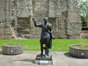
- Plaque 2 – City Wall at Tower Hill (Statue of Trajan): This is located in the garden area by Tower Hill tube station where there is a large section of Roman Wall topped by medieval stonework.
- Plaque 3 – City Wall at Cooper’s Row: This is located on the east side of the Wall in the courtyard.
- Plaque 4 – City Wall at Emperor House: This is located on the east side ground level of the Urbanest student accommodation on this site.
- Plaque 5 – Aldgate (City Gate): This plaque is located on a low wall on the front of John Cass School, facing Fenchurch street, behind a bicycle rack.
- Plaque 6 – City Wall at Duke’s Place: This plaque is inaccessible due to closure of the subway.
- Plaque 7 – City Wall at Bevis Marks: This plaque is located on the south side of Bevis Marks by the Synagogue.
- Plaque 8 – Bishopsgate (City Gate): This plaque no longer exists.
- Plaque 10 – City Wall at All Hallows: This plaque no longer exists.
- Plaque 12 – City Wall at St. Alphage: This plaque no longer exists.
- Plaque 13 – Cripplegate (City Gate): This plaque is located at the corner of Wood Street and St. Alphage Garden.
- Plaque 14 – City Wall & Towers: This plaque is located on the railings near the southeast corner of St. Giles Cripplegate church.
- Plaque 15 – St. Giles Cripplegate Tower: This plaque is where the stone pathway meets dirt and grass in a back courtyard of the Barbican Estate.
- Plaque 16 – Barber-Surgeons’ Hall Tower: This plaque no longer exists.
- Plaque 17 – City Wall & Medieval Tower: This plaque no longer exists.
- Plaque 18 – Roman Fort West Gate: This plaque is located by the entrance to a car park under London Wall.
- Plaque 19 – City Wall & Roman Fort: This plaque no longer exists.
- Plaque 20 – City Wall & Roman Fort: This plaque no longer exists.
- Plaque 21 – Aldersgate (City Gate): This plaque is located on the east side of St. Martin’s-le-Grand.
References for Londinivm Avgvsta
- Chapter 3 of The Towns of Roman Britain by John Wacher (2nd Ed., BCA, London, 1995);
- Temples in Roman Britain by M.J.T. Lewis (Cambridge 1966);
- The Roman Inscriptions of Britain by R.G. Collingwood and R.P. Wright (Oxford 1965).
Map References for Londinivm Avgvsta
NGRef: TQ3281 OSMap: LR176/177; Londinium.
Roman Roads near Londinivm Avgvsta
Ermine Street: N (28) to Bravghing Stane Street: SSW (14) to Ewell (Surrey) NE (32) to Great Dvnmow (Essex) River Stort Downstream: N (23) to Harlow S (44) to Hassocks (West Sussex) Iter II/Watling Street: NW (11) to Svlloniacis ENE (14) to
Durolitum(Harold Wood, Romford, Greater London) W (18) to Pontes (Staines, Surrey) Watling Street: ESE (13) to Noviomagvs Cantiacorvm (Crayford, Greater London) SSW (17) to Titsey (Surrey) River Stort Downstream: N (23) to Old Harlow
Plan of London (Londinium) Roman Settlement
Sites near London (Londinium) Roman Settlement
- London Mithraeum (0 km)
- London's Roman Amphitheatre (0 km)
Amphitheatre - Billingsgate Roman House and Baths (1 km)
Roman Houses - Watling Street (3 km)
Roman Road - Highgate Wood Pottery Factory (9 km)
Pottery - Crofton Roman Villa (20 km)
Villa - Brockley Hill (Sulloniacae) Roman Settlement (21 km)
Claudian Auxiliary Fort (AD 43–54), Pottery and Vicus - Little London, Chigwell (Durolitum) Roman Settlement (25 km)
Minor Settlement - Lullingstone Roman Villa (26 km)
Temple Or Shrine and Villa - Ewell (26 km)
Major Settlement


.jpg)