Agricola's Forts and Camps
By March AD 82, as Agricola began his sixth season, several forts had already been established up to the Tay estuary, serving as winter quarters for some troops. Agricola might have been stationed in Carlisle (Luguvalium), or possibly further south in the York (Eburacum) fortress. However, the majority of his army was housed in the forts across the Central Lowlands and Southern Uplands. These forts were designed to offer decent winter lodging with their timber structures. The turf and timber ramparts were robust enough to last throughout the year with minimal maintenance from a small, permanent garrison, well-protected behind solid timber gates. With the start of the campaign season, the troops were constantly on the move for extended periods, engaging in combat with the enemy, and thus only required temporary accommodations during their movements.
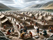
Years of aerial reconnaissance over the untouched agricultural lands of Perthshire, Angus, Aberdeenshire, and Moray have uncovered numerous rectilinear patterns indicative of Roman marching camps. Unlike permanent forts, these were temporary structures, meant to organize troops in tents made of leather (as per Caesar’s description in “BCiv. 3.13”) – the actual material of Roman tents. Even high-ranking officers stayed in these tents, with more elaborate versions for those of higher status, and the commander’s tent, the largest of all, located centrally. The primary purpose of these marching camps was to maintain order within a military force in often unfamiliar territories. Furthermore, it’s noted that the well-guarded perimeters of these camps also served to prevent secretive desertions.
The defenses of these camps typically consisted of a shallow ditch around the perimeter. The excavated soil from these ditches was used to create an earthen rampart, and it’s possible that a palisade was erected on top of this rampart. There were openings for gateways, usually one on each side of the camp, but longer ramparts might feature two. Instead of timber gates, these entrances were secured by extended segments of rampart and ditch. These extensions either curved outward, forming a semicircular shape that was part of the camp’s rampart, or they were positioned detached, some distance in front of the entrance.
The soldiers named the first type of gateway a “clavicula,” or “little key,” likely due to its resemblance to the bulky, curved keys common in ancient times. The name also carried a humorous connotation for the soldiers, as securing a camp entrance with a “little key” must have seemed amusingly understated. The second type of gateway defense was called a “titulus.” This term could imply a resemblance to a placard (the more common meaning of the word) lying flat on the ground. Additionally, the term resonated with soldiers’ slang, humorously referring to the feature as a “little Titus.”
Years before, during Rome’s Jewish War (AD 66–74), an observer noted the remarkable speed at which the Roman army could construct a temporary encampment, remarking that “it is as if a town is produced in a moment” (Josephus, Bell. Jud. 3.83). This observer, the historian Josephus, detailed the process: leveling the ground, marking the perimeter, arranging the interior into rows for tents, and swiftly constructing the rampart. He attributed this efficiency to the number and skill of the workers (Josephus, Bell. Jud. 3.84). Josephus also mentioned that these camps typically had four gates, one on each side, to facilitate the movement of draft animals and to allow for rapid deployment in emergencies (Josephus, Bell. Jud. 3.81).
While these descriptions generally match the Roman marching camps in Scotland, variations exist. For instance, the Raedykes Camp in Aberdeenshire, despite 18th-century claims of it being Calgacus’ stronghold, is clearly Roman. This 38-hectare (94-acre) camp is broadly rectangular but with notable deviations: the north rampart has a pronounced re-entrant around the north gate, and the west side shifts eastwards, making the south side much shorter than the north. Contrary to Josephus’ account of four gates, Raedykes has six, with two on each long side, each around 15 meters (50 feet) wide and secured by a titulus positioned about 11 meters (36 feet) outside. A complete wheel, indicative of wagon access, was once recovered from this site during 19th-century excavations, but it has since deteriorated due to lack of preservation.
The strategic placement of gateways, facing each other in pairs, established two (or three, in cases of six gates) primary routes within each camp. This arrangement led to the formation of a principal longitudinal road (termed the via praetoria by Roman surveyors) and one or two lateral roads, the main one being the via principalis, which passed by the commander’s tent. These roads laid the foundation for an organized grid pattern for setting up the soldiers’ tents. Josephus describes this process: “After fortifying their position, they camp by companies in a calm and orderly fashion. They carry out all tasks, like gathering wood and provisions, with discipline and security. Water is also fetched for each company. Meals are taken collectively, not individually whenever desired, and trumpets sound for sleeping, guard duty, and waking up, as no activity takes place without a signal” (Jos., Bell. Jud. 3.85–86).
Traditionally, archaeologists have focused their limited resources on studying the defenses and gateways of marching camps, as these are the most prominent features in aerial photographs. The interior was often overlooked under the assumption that it would yield little archaeological information, being primarily a site for tents. However, the discovery of lines of refuse pits in camps like Glenlochar, Dalginross, and Stracathro, previously dismissed as anomalies, hinted at the possibility of these camps being used for days or weeks, not just for overnight stays as previously thought.
A breakthrough came in 2000 during an excavation at Kintore (near Inverurie, Aberdeenshire) when the camp was threatened by road construction. Archaeologists found not just common pits, likely used as latrines, but also over 120 stone-lined field ovens. The exact layout of these ovens in relation to the tent lines remains unclear, but their presence suggests that Roman marching camps were more sophisticated than previously believed.
Marching camps of varying sizes have been discovered as far north as Bellie, near Elgin in Moray, on the Spey river’s floodplain. Over time, archaeologists have attempted to date these camps to different historical periods, a task closely associated with the late Professor Kenneth St Joseph, a pioneer in aerial reconnaissance. From 1950 until his retirement in 1980, St Joseph proposed several classifications for these camps, primarily based on their size and, to some extent, shape. However, one of his classifications was unique, focusing on the design of the camp’s gate defenses. The distinct ‘Stracathro’ gateway style, featuring both internal and external claviculas along with an oblique spur to narrow the entrance, is found in about a dozen camps, all in Scotland. While camps like Barnhill, Beattock 1 Temporary Camp, Dalswinton Bankhead Forts I & II, and Castledykes Marching Camp 1 are similar in size and located in the southwest, the diversity among other Stracathro-type camps suggests they don’t belong to a single group. The association of this gateway design with known Flavian forts at Stracathro Roman Fort and Dalginross Roman Forts, the latter observed as a standing monument by William Roy, suggests these camps date back to around Agricola’s governorship.
St Joseph also identified a series of large ‘110-acre camps’ including Raedykes, Normandyke Marching Camp, Deer’s Den, Kintore Temporary Camp 1, Ythan Wells Temporary Camp 1, and Muiryfold Temporary Camp. These camps, averaging 44.5 hectares (110 acres) though Raedykes is slightly smaller, form a line from the Mounth towards the town of Keith. While concrete dating evidence is scarce, the camp at Ythan Wells seems to overlay a Stracathro-type camp.
St Joseph observed a longer interval between Kintore and Ythan Wells, which could be halved by detouring slightly westward to Durno. There, a 58-hectare (143-acre) camp, shaped like a twisted rectangle and first noticed in 1975, lies near the river Urie. Like others in the ‘110-acre’ series, it features six titulus-guarded gates. This largest camp north of the Forth–Clyde isthmus is seen as a key Roman assembly point for the battle of Mons Graupius, especially given its proximity to the notable Bennachie mountain.


