Pevensey (Anderitum) Roman Fort
Saxon Shore Fort
Pevensey Castle was established as one of the nine Late Roman forts on the British side of the Saxon Shore. It was one of the last forts built during the third century and was one of the largest. The fort is named as Anderitum, apparently meaning “great ford”, according to the Notitia Dignitatum, a list of Roman “dignities” (i.e. public offices) as of the 5th century.
Pevensey Castle was constructed by the Romans on a spur of sand and clay that stands about 10 metres (33 ft) above sea level. In Roman times this spur was a peninsula that projected into a tidal lagoon and marshes, making it a strong natural defensive position. A harbour is thought to have been situated near the south wall of the castle, sheltered by a long spit of shingle where the village of Pevensey Bay stands now.
There was some evidence for prehistoric and first and second century Roman activity in the area, however the military occupation started in the fort which was built Pre-fort occupation was limited in the 1st to 2nd centuries AD,
We know the stone fort was built in circa 293-300 AD from tree-ring dating. Two coins that were found immediately above the construction debris, which were from the reigns of Carausius and Allectus would narrow this down further to the mid-290’s. Military occupation lasted until at least until the end of the 4th century. Occupation continued in some form until it was sacked in circa 470 AD by the Saxons.
Pevensey Vicus
While most Roman forts had a civilian settlement or vicus outside the fort, as Pevensey Roman Fort was built on a peninsular there was no room for one. Archaeologists have discovered a childs amulet, and hairpins, showing that women and children lived in the fort alongside the soldiers.
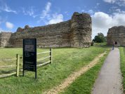
What does the Roman fort at Pevensey Look Like?
Pevensey (Fig. 12b) is oval in shape, with an area of over 8 acres. Its walls are 12 feet thick and stand 28 feet high; they are built on a framework of timber sleepers embedded in the surface of a chalk and stone foundation, and have U-shaped bastions and tile bonding-courses. The gates, flanked by towers, are 10 feet wide, and there is a postern curved in such a way that a person entering cannot see into the fort.” (Collingwood, p.53)
You will note that the plan of the fort is oval not rectangular – which most Roman forts are built – this was because the fort originally stood on a slender peninsula on the west side of the entrance to a wide bay. As it was surrounded on three sides by march and water the fort was built to fit the peninsula.
Classical References to Anderitum / Anderida
The name of the Roman station at Pevensey is first mentioned in the Notitia Dignitatum of the late-4th/early-5th centuries where it appears as Anderide, between the entries for Rutupiae (Richborough, Kent) and Portus Ardaoni (Portchester, Hampshire). It was one of nine forts around the south and east coasts commanded by the Comes Litoris Saxonici per Britanniam, or the ‘Count of the Saxon Shore’.
Whether or not these forts were established as a coherent defensive system is not clear, but some may have had naval detachments, working also with ships based at coastal forts in northern France. The Notitia mentions a fleet, the classis Anderidaensis, which took its name from Anderida.
The Pevensey fort is last mentioned in the Ravenna Cosmology of the seventh century, in which the name is recorded as Anderelio Nuba (R&C#68), between the duplicated entry for Iacio Dulma (Towcester, Northamptonshire) and the unknown station Mutuantonis located somewhere in south-east England.
There is some confusion about the name of the Roman fort. The DOE name plaque, the curator, documentary evidence shown to the investigator by the curator, and the 1952 official guide called it Anderida. Only the OS and the 1970 revised pamphlet call it Anderita. The name ‘Anderita’ or ‘Anderida’ :- ‘Anderida’ is the traditional name, but Jackson discusses the orthography in detail and concludes (a) … “a Celtic ‘Anderida’ is meaningless, whereas to the eye of the Celticist the correct form is obviously Roman-British ‘Anderitum’ or rather its plural ‘Anderita’, ‘The Great Fords’,” and (b) “It is to be hoped that the unwarranted ‘Anderida’ will be dropped in future, and ‘Anderita’ substituted.” Name ‘ANDERITVM’ accepted for 4th.edition R.B.Map.
The Epigraphy of Anderitum / Anderida
Although there are no inscriptions on stone recorded in Volume I of the R.I.B., many roofing tiles have been unearthed within the Pevensey defences which have been stamped on the back with one of the oldest Roman texts in Britain (vide infra). They likely record the activities of the last known Roman governor to campaign in Britain, Stilicho the Vandal, who has also been connected with the series of signal stations along the north-eastern coast between Huntcliff in Cleveland and Filey in North Yorkshire. This man was the most favoured general of the emperor Honorius, the younger son of Theodosius, who ruled the Western Empire from his citadel at Ravenna between 395AD and 423 (vide supra).
Roman Roofing Tiles
“[Property of] the emperor Honorius, from Anderida“
(Burn 231; RIB II; stamped tiles)
The Garrison Unit(s) of Anderida
The only record of any of the fort’s garrison units is contained in the Notitia Dignitatum mentioned above, where, included among the forces “at the disposal of the Right Honourable Count of the Saxon shore in Britain” there is the entry for Pevensey shown below.
The Pevensey Entry from the Notitia Dignitatum
“The commander of the Company of Abulci¹ at Anderida“
- The Abulci possibly hailed from the Roman town of Abula in Hispania Tarraconensis mentioned by Ptolemy, now known as Avila near Madrid in central Spain. They could equally be a little-known tribe from Germany.
Later occupation of the Roman Fort at Pevensey
By the mid 7th century occupation had been re-established within the walls. Covering almost 4ha, the fort survives in the form of substantial ruins and buried remains. It is enclosed by a massive defensive wall which was strengthened by irregularly-spaced, externally projecting semi-circular bastions. The Middle and Late Saxon occupation includes a possible royal palace, hinted at by a number of luxury objects found on the site.
By the mid 9th century it had become a small fishing port and a centre of salt production. William the Conquerer landed at Pevensey in 1066, and the Norman army are believed to have made use of the Roman fort as one of their first armed camps.
Other Roman Sites in the Locale
There is a villa at Eastbourne (TV6198), four miles to the south-west along the coast. The Roman pottery kiln at Arlington (TQ5207), lies on the line of the suspected road to the minor settlement at Hassocks, and a substantial Roman building has been found at Newhaven (TQ4401) along the route of the possible coastal road to Brighton and Noviomagus (Chichester).
References for Anderitvm / Anderida
- Roman Britain and the Roman Navy by David J.P. Mason (Tempus, Stroud, 2003);
- The Roman Shore Forts – Coastal Defences of Southern Britain by Andrew Pearson (Tempus, Stroud, 2002);
- A Guide to the Roman Remains in Britain by Roger J.A. Wilson (Constable, London, 2002, 4th ed.);
- Roman Britain by Peter Salway (Oxford 1981);
- The Archaeology of Roman Britain by R.G. Collingwood (Methuen, London, 1930).
Map References for Anderitvm / Anderida
NGRef: TQ6404 OSMap: LR199
Roman Roads near Anderitvm / Anderida
Possible Road: NNW (33) to Holtye (Sussex) Possible road: W (24) to Hassocks (West Sussex) Possible Coastal Road: W (24) to Brighton (nr. Brighton & Hove, Sussex)
Sites near Pevensey (Anderitum) Roman Fort
- Holbeanwood / Bardown (26 km)
Iron Mine, Iron-work and Mine - Novus Portus (Brighton)? (33 km)
Probable Port - Hassocks Cemetary (36 km)
Cemetery - Hurstpierpoint (38 km)
Pottery and Villa - Holtye (39 km)
Iron-work - Lancing Down Temple (46 km)
Temple Or Shrine - Chanctonbury Ring Temples (51 km)
Temple Or Shrine - Chanctonbury Ring Hill Fort (51 km)
Iron Age Hillfort and Temple Or Shrine - Maidstone (53 km)
Villa - Findon Temple (54 km)
Temple Or Shrine


