Caernarfon (Segontium) Roman Fort
Flavian Auxiliary Fort (AD 69–96), Hadrianic Auxiliary Fort (117 to 138) and Vicus
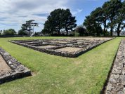
Built nearly two thousand years ago, this strategically located fort at the frontier of the Roman Empire thrived for over three centuries.
Segontium was established by Agricola in AD 77 after his brutal suppression of the Ordovices tribe’s rebellion. Designed to house a 1,000-strong regiment of auxiliary infantry, it was connected to the major legionary bases at Chester and Caerleon by Roman roads.
Thanks to the discovery of coins, we know the Romans remained here until around AD 394 – no other fort in Wales was occupied for as long. Segontium not only controlled access to the fertile, mineral-rich island of Anglesey but also played a key role in defending the Welsh coast from Irish pirates.
Even after the Roman legions departed, Segontium became part of Welsh legend, referred to as Caer aber Seint – “the fort at the mouth of the Saint River” – and is mentioned in The Dream of Macsen Wledig, one of the ancient stories from the Mabinogion.
Table of Contents
History of Segontium Roman Fort
The territory was originally controlled by the Ordovices tribe. Like other Welsh tribes, such as the Deceangli in north east Wales and the Silures in the south, they had warlike tendencies and were influenced to a greater or lesser extent by a druidic cult that was centred on Anglesey. The Romans had invaded North Wales as early as AD 47 but military priorities elsewhere forced a withdrawal. General Paulinus led a new conquest of North Wales in AD 60 which included the storming of Anglesey and extermination of the druids there. However the outbreak of the Boudica rebellion in Eastern England meant Roman forces had to withdraw. Finally, in AD 77 General Gnaeus Julius Agricola launched another invasion of North Wales which resulted in the defeat of the Ordovices tribe. The fort was also built to command the Menai Straits and thus to enable the capture of the island of Mona (Anglesey) which it overlooked to the north-west.
Segontium was destroyed by fire around AD 110 – likely to have been done by the Romans themselves to enable easy recovery of the iron nails that held the structure together. The fort was rebuilt in stone around AD 130 although it underwent a series of substantial modifications during that period. In particular in the late third century AD a large courtyard building, generally interpreted as an administration complex, and a bath house were built in the fort’s south-eastern quadrant. This suggests the fort may have served as an administrative centre for North Wales although it is more likely this was done from Chester (Deva), base of the Twentieth Legion (Legio XX Valeria Victrix). The site underwent a number of reconstruction phases during its lifetime and was occupied until c.383AD. In the late third century AD a large courtyard building and a bath house were built in the fort’s south-eastern quadrant, which suggests the fort may have served as an administrative centre for North Wales.
What did Segontium Roman Fort Look Like?
The space within the rampart available for occupation measured about 510 by 415 feet, giving an area of about 4½ acres. The fort was aligned towards the south-west, probably on the Ordovician stronghold on Dinas Dinlle at the south-western end of the Menai Strait separating Mona Insula (the Isle of Anglesey) from the coast of Wales. Defences consisted of an 18 feet wide clay rampart, a berm varying in width between 3 to 7 feet, then a double ditch system, with two identical ditches, 17 feet wide separated by a gap 15 feet wide. The four gateways and the internal buildings were originally built in timber, and were later replaced by stone.
When the principia or regimental headquarters in the centre of the camp was excavated by Mortimer Wheeler during 1921-23, he was able to distinguish four separate phases of building and alteration ranging from the early-second to the late-fourth centuries. The sunken strong-room beneath the sacellum or regimental shrine in the centre of the rear-range of the principia yielded no less than 114 coins.
Flavian Fort Destroyed
The original Flavian timber-built fort was apparently burned in late Trajanic times, and was either abandoned or destroyed, to be replaced by a stone fort during the reign of Hadrian. Antonine samian ware and a Severan rebuilding inscription suggest continued occupation throughout these times, and repairs to the strong-room floor around 235AD, along with building repairs, new road surfaces and well-clearance dated around 350-360 prove that the fort remained of key importance until at least the late-fourth century. The latest coin from the site is that of Gratian (367-383).
During excavations over the years at Caernarfon a number of animal bones have been uncovered, including those of Ox, Sheep, Pig, Red Deer, Boar, Hare and Wolf; the latter animal very likely being hunted and killed for sport and as a means of pest control. (Davies)
The area hosts Hen Waliau (Segontium) Fortlet, and Caernarfon (Segontium) Bath Housein the fort’s south-west corner.
Excavations at Segontium
SH485624 – Excavations conducted outside the north-east gateway (porta decumana) of the fort in 1971 revealed that the road issuing from this gate remained unchanged from Flavian times, when the gateway was constructed of timber, until about 330AD when the external defences were altered. The causeway to the gate was cut-through and the W-profile ditch was re-cut to a more typical V-shape. After this time, access through the gateway was achieved via a wooden bridge, evidence for which has been found.
The Garrison Units
Based on archaeological findings in the interior of the fort it has been suggested that it was built to house a Cohors Equitata Quingenaria, a five-hundred strong mixed unit of infantry and cavalry. Other similar forts have been identified at Canovium (Caerhun), Coelbren and Castell Collen, all in Wales, which likely housed garrison units of the same type. A dedicatory inscription was later found which proved this premise (vide infra).
RIB 430 - Commemorative slab - Caernarvon (Segontium)
The Emperor-Caesars Lucius Septimius Severus Pius Pertinax Augustus and Marcus Aurelius Antoninus Pius Augustus and Publius Septimius Geta, most noble Caesar, restored the channels of the aqueducts fallen in through age for the First Cohort of Sunicians …
[... ...]VREL ANTONINVS
[... ...] ET ⟦[ ...]T [... ...]B C[...]⟧
[...] AQVAEDVCTIVM VETVS
[...]BS COH I SVNIC RESTIT
[...] ΛṚẸ [...]
[...] NL [...]
[Brit. xliv (2013)] RIB reproduces Collingwood’s 1929 drawing of fragments (a) and (b), but the 1852 drawing of (b) when it was discovered, published by Foster in Arch. Camb. n.s. 4 (1853), pl. following p. 72, shows in spite of some inaccuracies that a minor fragment to the left preserved the AQ of aquaeductium. This was noticed by A.R. Birley, The Roman Government of Britain (2005), 187, n. 23.

Religion in Roman Caernarfon
Segontium Mithraeum
There are five known temples in Britain dedicated to the ancient Persian sun-deity Mithras; three on Hadrian’s Wall each containing altars dedicated by the military, one civilian temple in London which is perhaps the most famous, and another military establishment at Caernarfon. These temples were invariably long, low buildings, with no natural light apertures apart from the entrance portal, meant to imitate the cave in which the god Mithras slayed a mythical bull.
RIB 429 - Altar dedicated to Minerva - Caernarvon (Segontium)
To the goddess Minerva Aurelius Sabinianus, actarius, willingly and deservedly fulfilled his vow.
MINERVAE
AVR SABINI
ANVS ACT
V S L M
For actarius see Glossary.

This stone was found in the south-eastern part of the fort and was associated with a late (third-century?) bath-house and administration block. It has been suggested that by this time, the Segontium fort was used as the centre of administration for North-West Wales and Anglesey, encompassing the tribal territories of the Ordovices and its adherent minor tribes the Gangani and the Segontiaci, thus covering the modern counties of Gwynedd and Anglesey. It is possible that the neighbouring tribe the Deceangi of Clwyd were also administrated from here, though it is more likely that this region came under the aegis of the Legionary Fortress at Deva (Chester, Cheshire).
Milestones from the Caernarfon Area
RIB 2264 - Milestone of Caracalla - (unknown)
To the Divinities of the Emperors: the Emperor Caesar Marcus Aurelius Antoninus Pius Felix Augustus, conqueror of Arabia, ..
IMP CAESAR M
AVREL ANTONINVS
PIVS FẸ[...]IX AVG ARAB
[...] IX
Caracalla, A.D. 212-17.
Classical References to Segontium – The Place of the Segontii?
The Roman name for Caernarfon is recorded in the Antonine Itinerary of the second-century AD as Segontio, and is placed 24 Roman miles from Canovium at the starting-point of Iter XI, the route from Caernarfon to Deva (Chester, Cheshire). Not mentioned in Ptolemy’s Geographia, the name appears as Seguntio in the The Ravenna Cosmography, following the unknown Mediomanum entry.
The accepted Roman name for Caernarfon is Segontium. The name could mean ‘the place or home of the Segontii‘; implying that there was a tribe of that name in the area or it’s name may comes from that of the river: ‘sego-‘ , meaning ‘vigorous’, which is hidden in its modern form, Seiont. The modern Welsh place-name Caernarfon is readily translated as ‘the fort at the river mouth’.
References for Segontivm
- Chronicle of the Roman Emperors by Chris Scarre (Thames & Hudson, London, 1995);
- Britannia iii (1972) p.299; The Roman Military Diet by R.W. Davies, in Britannia ii (1971) pp.122-142;
- The Roman Frontier in Wales by Nash-Williams (1969) pp.59-64;
- Temples in Roman Britain by M.J.T. Lewis (Cambridge 1966);
- The Roman Inscriptions of Britain by R.G. Collingwood and R.P. Wright (Oxford 1965);
- The Archaeology of Roman Britain by R.G. Collingwood (Methuen, London, 1930).
Map References for Segontivm
NGRef: SH 485 624 OSMap: LR114/115, OL17
Roman Roads near Segontivm
ENE (5) to Caemetta ENE (20) to Canovivm (Caerhun, Gwynedd) Possible road: S (12) to Penllystyn (Gwynedd) By coracle across the Menai Straits: NW (1) to Mona (Isle of Anglesey)
Sites near Caernarfon (Segontium) Roman Fort
- Caernarfon (Segontium) Courtyard house with Baths (0 km)
Bath House - Hen Waliau (Segontium) Fortlet (0 km)
Fortlet - Cae Metta (6 km)
Iron Age Hut Groups - Dinas Dinorwig (7 km)
Iron Age Hillfort - Aberffraw (15 km)
Possible Roman Fort - Derwydd Bach Camp (17 km)
Marching or Temporary Camp - Pen Llystyn Roman Fort (17 km)
Flavian Auxiliary Fort (AD 69–96) - Ynys Môn and Ynys Gybi (18 km)
Temple Or Shrine - Pen y Gwrhyd Marching Camp (19 km)
Marching or Temporary Camp - Din Sylwy (21 km)
Minor Settlement


