The Stanegate Frontier c.AD105
Roman Frontier Systems in Britain
Although the process had probably started in 87AD (q.v. Hobley) and had been going on for about 20 years in four gradual stages (Breeze & Dobson, p.8), the total abandonment of lowland Scotland is evidenced only by the destruction of the forts on Dere Street at Newstead in the Scottish Borders and Corbridge (Corstopitum) in Northumberland, also the burning of forts at Glenlochar on the Galloway Peninsula, Dalswinton in Nithsdale in Dumfriesshire, Cappuck and Oakwood in the Scottish Borders and High Rochester in Northumberland, all of which were abandoned sometime between A.D. 100 and 105 (Salway p.165). It has become evident from excavations conducted on these forts and others, that the destruction layers found are not to be taken as evidence of barbarian action against these garrison forts, but rather to indicate an orderly, though piecemeal, withdrawal of troops from northern Britain during the late-Flavian and Trajanic periods, very likely in order to promote frontier wars in other parts of the Roman empire (Jones & Woolliscroft, chap.2).
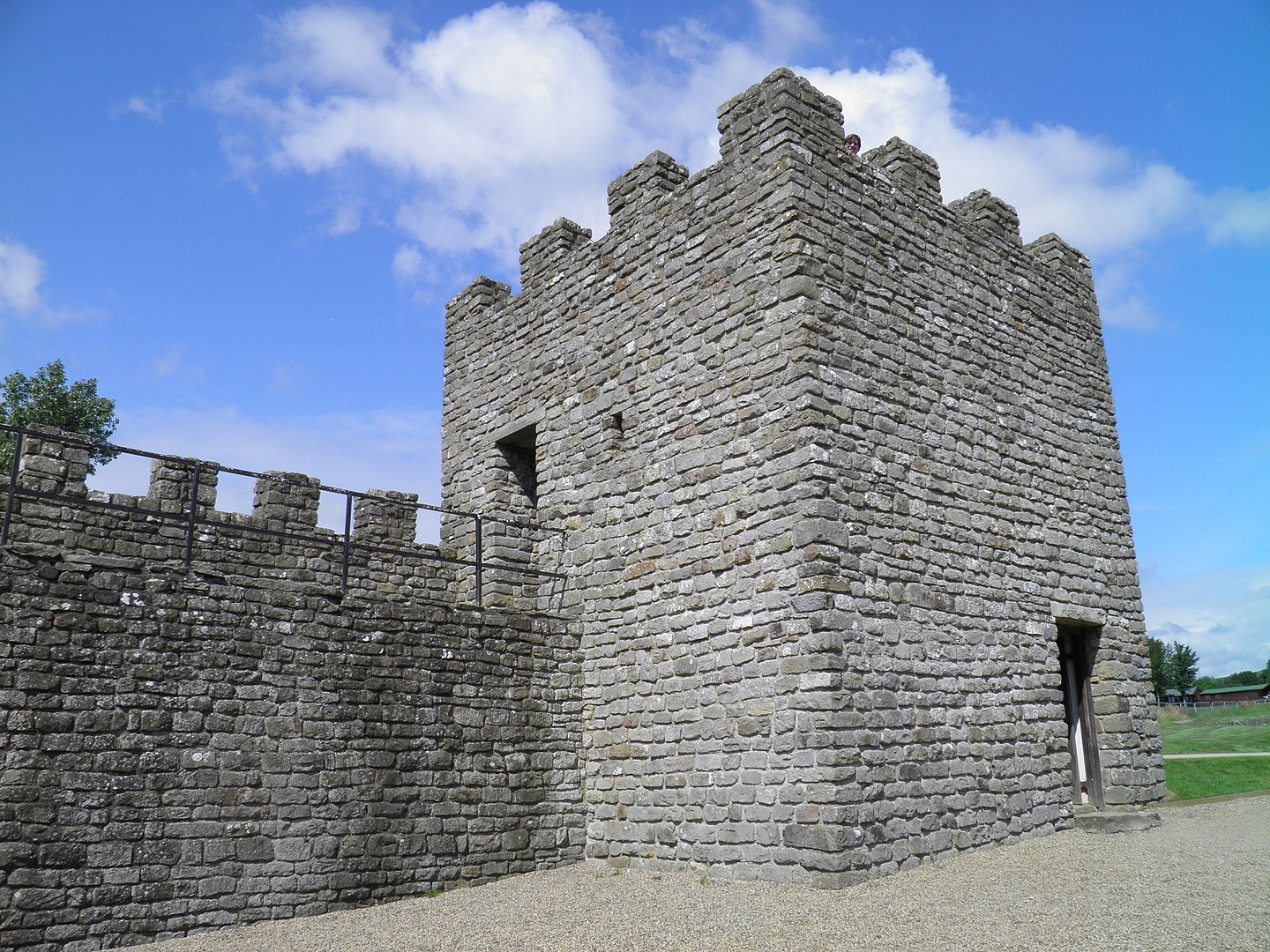
The military withdrawal of the Roman occupation army in Scotland was seemingly accompanied by the establishment of a northern ‘frontier’ zone based upon an extant line of forts running across northern England from the supply depot at Corbridge (Corstopitum) on the Tyne to the Flavian fort at Carlisle (Luguvalium) on the Solway, both of which sites were notable as they were positioned upon the two main lines of advance into lowland Scotland; Dere Street (Margary #8e-8g) which ran through the lands of the VotadiniVotadini[/link_post] in the east, and the imperfectly-known western route through Annandale (Margary #7f) and the lands of the NovantaeNovantae[/link_post]. Between these two military highways a number of forts were established across Northern England to act as a ‘buffer’ zone between the recently conquered lowland tribes of Scotland and the tribes to the south, the Brigantes in the east and the Carvetii Carvetii[/link_post] in the west, both of which had been brought under the hobnailed sandal of Rome almost a generation previously. These ‘buffer’ or ‘frontier’ fortifications, the most famous being that at Chesterholm/Vindolanda, were arranged along the line of a later Roman road (Margary #85) nowadays known by its Medieval name, the Stanegate, from Saxon stan ‘stone’ + Norse gata ‘road’ (q.v. Selkirk, p.88).
The Stanegate Fortifications Listed from East to West
| Washing Wells (Tyne & Wear) | 4½ acres (c. 1.8 ha) |
| c. 15 miles (24 km) | |
| Corstopitvm (Corbridge, Northumberland) | c. 9 acres (c. 3.6 ha) |
| c. 7½ miles (12 km) | |
| Newbrough (Northumberland) | 0.85 acres (c. 0.34 ha) |
| c. 6¼ miles (10 km) | |
| Vindolanda (Chesterholm, Northumberland) | 7 acres (c. 2.8 ha) |
| c. 3½ miles (5.6 km) | |
| Haltwhistle Burn (Northumberland) | 0.8 acres (c. 0.3 ha) |
| c. 3 miles (5 km) | |
| Magnis Carvetiorvm (Carvoran, Northumberland) | 3½ acres (c. 1.45 ha |
| c. 2 miles (3.3 km) | |
| Throp (Northumberland) | ¾-acre (0.3 ha) |
| c. 2½ miles (4 km) | |
| Nether Denton (Cumbria) | c. 7¾ acres (c. 2.9 ha) |
| c. 3¼ miles (5.2 km) | |
| Boothby (Cumbria) | c. 1 acre (0.4 ha) |
| c. 2½ miles (4 km) | |
| Old Church (Brampton, Cumbria) | 3¾ acres (1.5 ha) |
| c. 7¾ miles (12.5 km) | |
| Lvgvvalivm (Carlisle, Cumbria) | c. 8 acres (c. 3.2 ha) |
| c. 5¼ miles (8.5 km) | |
| Burgh-by-Sands (Cumbria) | 5.13 acres (2.07 ha) |
| c. 5½ miles (8.8 km) | |
| Kirkbride (Cumbria) | 6 acres (c. 2.4 ha) |
These major fortifications were also accompanied by a couple of Signal Stations: one on Barcombe Hill in Northumberland, between the forts at Chesterholm and Newbrough, and another at Mains Rigg in Cumbria, between the fort at Nether Denton and the small fort at Throp. These small installations are both thought to have been built to maintain communications along the line of the Stanegate road, but the system appears incomplete; it is quite possible that other stations of the same type await discovery.
Refurbishment and Reinforcement
The fortifications already established along the line of the Stanegate were rebuilt and re-garrisoned. The fort at Corbridge (Corstopitum) was rebuilt and its garrison changed c. A.D. 105, a date which can be fairly certain as its rampart overlay burnt debris concealing a hoard of coins dating no later than 98 while a coin of 103 was found within the rampart make-up (Frere, p.123). The forts at Chesterholm, Carvoran and Nether Denton all show signs of multiple periods of occupation, with the earliest phases possibly being established during the second campaign season of Julius Agricola (vide Tacitus Agricola XX.ii), these sites had been in occupation since 90 and all underwent a change of garrison or other modification around 105 (Bowman, figs. I & II). The 3¾ acre fort at Old Church Brampton shows no such indications and would appear to have a Trajanic foundation, added to the Stanegate scheme around 105 (Jones & Woolliscroft, pp.58/9).
The garrison along the Stanegate was also supplemented by the establishment of new ‘fortlets’ and ‘small forts’ between the larger stations, at Newbrough, Haltwhistle Burn and Throp in Northumberland and at Boothby in Cumbria. Here, for the first time in Britain we see individual auxiliary units being split into smaller detachments and stationed in undersized forts and in fortlets without administrative buildings; in this instance sited to protect a military highway. In addition, beyond the known termini of the Stanegate there were further forts, at Burgh-by-Sands overlooking the Solway estuary and at Kirkbride on the River Wampool in the west (Breeze, chap.4). Another fort overlooking the Tyne at Washing Wells near Gateshead in the east was discovered by aerial photography in 1970. This trapezoidal fort of turf-and-timber covering about 4½ acres (c.1.8 ha) evidences several phases on A.P.’s and is thought to date to the Trajanic period, perhaps an eastwards extension of the Stanegate system (Maxwell & Wilson, p.27; St. Joseph, p.215).
Evidence of Other Frontier Structures
The recent discovery of a timber palisade running beneath the Trajanic fort at Burgh-by-Sands and traces of the same linear work associated with a timber watch-tower along the whale-backed ridge at Fingland, coupled with evidence of a Roman road east of Kirkbride, aligned towards the fort at Burgh-by-Sands, points to some sort of frontier work, very-likely contemporary with the Stanegate system and evidence of pre-Hadrianic frontier management in northern Britain (Higham & Jones pp.22-29). This transient and elusive palisade and watch-tower system overlooking the Solway perhaps evidences a change in strategy on the part of the Roman military.
Studies based on the Trajanic frontiers on the continent at Taunus/Wetterau east of the Rhine in Germany and the R¶erstrasse in Raetia north of the Danube, where frontier works consisted of a series of forts along major river valleys, coupled with recent evidence from Britain, suggests that the Stanegate road was actually built at a later period than the forts along its line (Hodgson).
It is also significant that the hoard of writing-tablets belonging to the Trajanic occupation at Chesterholm/Vindolanda, which provides intimate details of the day-to-day running of this fort, says nothing about the existence of any limes in northern Britain at this time; although to be fair, the hoard mostly dates to the period pre-105, when a garrison was still being maintained in lowland Scotland (q.v. Bowman).
The stanegate crossed the River Irthing just to the north-west of the Brampton Old Church fort (NY 5069 6198) and the River Eden, into which the Irthing flows, was crossed by a bridge just north-east of the fort at Carlisle (Luguvalium) (NY 4005 5657), the modern bridge carrying the A7 trunk road nowadays using the same crossing point. The Stanegate crossed the River North Tyne just south-east of the modern town of Wall in Northumberland (NY 9093 6853); at this point the road lay just over one mile south of the later Hadrian’s Wall fort at Chesters (Cilurnum), but there is no known Trajanic fortification guarding this crossing.
Trajanic Fortifications on the Continent
Trajan is perhaps best remembered for his helical column in Rome celebrating his campaigns north of the Danube in the newly-won province of Dacia, also for his ill-fated campaign against Parthia. However, his embryonic frontier works in northern Britain, Germania and Raetia have already shown his attention given to the empire’s northern frontier and, before setting-out on his eastern expedition Trajan secured the borders elsewhere in the empire.
The Danube in Pannonia, after flowing eastwards for many miles makes a sharp turn to the south at the border fort of Cirpi about 20 miles north of the legionary fortress at Aquincum (modern Budapest, Hungary). Trajan in 103 divided Pannonia into two, the Superior province facing north across the Danube towards the Germanic Marcomanni and Quadi tribes, while the Inferior province faced the Sarmatae Iazyges to the east. The differing modes of fighting employed by these peoples required that each province had an army specially geared to counter the tribes they faced, these Trajan now provided. (q.v. Williams, chap.4; Hammond, map.24).
By Trajan’s time the empire had reached its physical limits, indeed, after Dacia the only direction in which this emperor thought expansion possible was to the east, as proven by his campaigns in Armenia and against Parthia. Although initiated primarily in order to seek personal gloria, he succeeded in acquiring a further two provinces, Mesopotamia and Assyria. The triumph was short-lived, however, for his health failed and he died of a stroke in Cilicia.
In southern Tunisia Trajan instigated a defensive system of clausurae or ‘closure walls’ across each of the valleys leading through the hills of the Djebel Asker and Djebel Zitouna south of the Chotts. Because they were dicontinuous these works could be easily circumvented by a determined attacker, but the pupose of a claustrum was not to prevent raiders but to deter the nomad and his dependents, who brought no great wealth to the empire. Nevertheless the interloper was left in no doubt that this marked the boundary of the Roman empire and no-one could enter it without knowing that they had done so (Williams, chap.6).
Trajan’s successor Hadrian almost immediately gave-up Mesopotamia and Assyria upon his accession, and although the gold-mines in Dacia assured the retention of this Trajanic acquisition, the Rhoxolani were allowed to ‘take back’ territory in the eastern part of the province. After eight-hundred years of almost continual expansion, the growth of the Roman empire had staggered, and now halted, even taking a step backwards in the east.


.jpg)