The Antonine Wall
The Northern Frontier Works of Emperor Antoninus Pius.
He [Antoninus Pius¹] conquered the Britons through his legate Lollius Urbicus,² another wall of turf being built after the barbarians had been driven back, …
Above extract from the Augustan History – Life of Antoninus Pius by Julius Capitolinus, translated by Anthony Birley
- Antoninus Pius was emperor from the death of his adoptive father Hadrian in July 138AD until his own death of natural causes in March 161.
- The propraetor Quintus Lollius Urbicus was governor of Britain from 138/9AD until c.143.
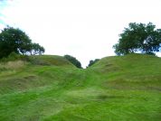
The Antonine Wall in Scotland was the northernmost frontier of the Roman empire. The barrier consisted of a line of auxiliary forts and fortlets connected by a continuous rampart wall and ditch. These entrenchments ran from Borrowstounness (Bo’ness or even Bridgeness) near Carriden in Edinburgh on the Firth of Forth, to Old Kilpatrick in the outskirts of Glasgow near Dumbarton on the Firth of Clyde. The wall ran for 39 miles – exactly half the distance of Hadrian’s defensive works further south – and passed along the central valley of Scotland formed by the River Kelvin in the west and the Bonny Water to the east. For the most part the defences were positioned to the south of these two streams, which themselves formed a natural line of defence against attack from the north.
Agricola First Fortifies the Forth-Clyde Line c.81AD
Roman forts were first established along the isthmus of the Forth and Clyde during the fourth campaign season of the celebrated eleventh governor of Roman Britain, Agricola in 81AD, after having swept through the lands of the Selgovae Celtic Tribe and Votadini in the Borders region of south-eastern Scotland the previous year (Tacitus’ Agricola 23). These Agricolan garrison forts were placed in the lands of the Caledonian Damnoni¹ tribe who occupied the area of modern Strathclyde and west Lothian, and who were probably conquered in that same year or perhaps during the previous winter (80/81AD). Either way, after cutting off any hope of reinforcements from the north, Agricola spent the next campaign season waging mahem upon the Novantae of the Galloway Peninsula in south-western Scotland and the following year (83AD) saw him in action to the north of the Forth and Clyde opening hostilities against the Venicones of Central and Fife. The next year, after defeating the combined forces of the Caledonian tribes in a decisive battle at Mons Graupius somewhere in the Grampian region of north-east Scotland, Agricola was recalled to Rome by the emperor Domitian and spent the rest of his life in retirement.
Agricolan fortifications along the line of the Antonine Wall have been identified at Mumrills and Castlecary in Central, and Bar Hill, Old Kilpatrick, Castle Hill and Cadder, all in Strathclyde.
- There was another British tribe named the Dumnonii inhabiting the extreme south-western tip of England.
Modern investigations have revealed that the Antonine Wall was built in four discernable stages, the primary forts being constructed first at (from east to west) Carriden, Mumrills, Castlecary, Bar Hill, Balmuildy and Old Kilpatrick, and the rampart wall started in the east, then the wall was advanced to Castlehill with many of the mile-fortlets being added, following this, the secondary forts were built and finally, the curtain wall was completed in the west between Castlehill and Old Kilpatrick (Keppie, esp. figs.2/4).
The release of a series of coins, of all denominations, comemmorating these ‘victories in Britain’ point to there perhaps being a certain amount of propaganda attributed to the building of the Wall; Antonine certainly took steps to ensure that S.P.Q.R. were well infomed about his gains in Britain (Spink, 639-646)
The Antonine Wall in the Ravenna Cosmography
We are told in a note to Nennius that there are 7 forts along the wall whilst the Ravenna Cosmography gives us 10 names along a “line” where Britain was “thinnest”. You may be forgiven for thinking that this should be good news, but unfortunately, we know of nineteen forts on the Wall, and with no epigraphic evidence to corroborate the place-names recorded in the R.C. we are unable to ascertain which name refers to which fort.
MEDIO-NEMETON & SUBDOBIADON are the sixth and seventh names on the Ravenna Cosmography. Most previous authors dismissed the note to Nennius and instead tried to shoe-horn all 10 names to forts along the wall, which gave such unconvincing name matches that none were accepted. These authors had ignored the possibility that the line from the Ravenna Cosmography extended beyond the end of the wall.
One exception is the name Velunia or Veluniate, the first in the list, which is generally assigned to the minor settlement at Carriden in Central. This station marks the eastern end of the Antonine Wall, and it is assumed that the The Ravenna Cosmography again adopts the convention of listing stations in frontier systems from east to west, as is the case with the fort’s along Hadrian’s Wall.
“Here are listed the stations within Britain joined together along a straight track where the Island is at its very thinnest from ocean to ocean, they are named:”
| R&C No. | Roman Name | Modern Name |
|---|---|---|
| 191 | Velunia | Velvniate (Carriden, Central) |
| 192 | Volitanio | unknown |
| 193 | Pexa | unknown |
| 194 | Begesse | unknown |
| 195 | Colanica | unknown |
| 196 | Medio Nemeton | unknown |
| 197 | Subdobiadon | unknown |
| 198 | Litana | unknown |
| 199 | Cibra | unknown |
| 200 | Credigone | unknown |
Above passage and table of names from the Ravenna Cosmology (7th century)
The Possible Birth place of St Patrick?
Most previous authors assumed Scotland was too barbaric to be the place of early an Saint whose family had Roman names, despite the early works on Saint Patrick telling us he was born in the area of Strathclyde. The coin evidence shows strong Roman links in the area toward the time of Saint Patrick. So it is quite reasonable that Christians with Roman names may have come to Strathclyde to escape the various persecutions against the Christians.
The town of Old Kilpatrick is known to be related to Saint Patrick and is a strong candidate for his birthplace. It also sits at the end of the Antonine wall, making it the seventh of the main forts along the wall – SUBDOBIADON. However, the Gaelic hymn of Fiacc records Nemthur as the birthplace of Saint Patrick and because it was recorded close to the relevant period, we must explain the mismatch between SUBDOBIADON and Nemthur.
If we postulate a mistake by a copyist joining MEDIO and NEMETON, we obtain not only a good match for Old Kilpatrick, but for three successive entries on the Ravenna Cosmography:
between the new 6th entry MEDIO and Balmuildy (Gaelic for Town of Muildy), the previous big fort,
between the new 7th entry NEMETON and Nemthur, and
between the new 8th entry SUB-DOBIADON and Dumbarton, the next obvious place with a Roman association and the likely port serving the wall.
MEDIO can be translated as “cultivated” or “meadow”, which best fits the site at Balmuildy, as this is the only large fort on a river in arable land.
“Nemeton” is generally agreed to mean a sacred place, which would suit the religious background of Saint Patrick.
The missing “M” in Dumbarton versus Roman “Dobiadon” may be explained by the local Welsh-like language in Strathclyde. If we postulate that “do” in “Do-biadon” is the same as Welsh douu/dom, with the meaning “settlement associated with (another)”, then SUBDO(M)BIADON can be translated: “Sub (Latin Under) + dou(m) (settlement associated with) + Biadon/Bia-don (the fort or hill of Bia). A weak “M” in the local dialect would explain the missing “M” in SUBDOBIADON compared to Dumbarton.
This weak “M” may also explains the extra “M” in Nemthur compared to the local place name of (Dou)notyr, now Dalnotter, a site located above an important ford of the Clyde. This ford was undoubtedly always an important location and likely to be settled in the Roman period. Thus it is an obvious candidate for the original location of Old Kilpatrick.
Finally, if we accept a variant reading of an inscription at found Mumrills fort, this inscription confirms Mumrills was VOLITANIO, the second entry of the Ravenna Cosmography.
In the field of British Roman place names, Roman names have often been allocated to places based on far less evidence than even one of these matches. So to have three names in a run is exceptionally good evidence, as it is very unlikely to occur by chance. This compels us to conclude that Old Kilpatrick is the NEMETON of the Ravenna Cosmography, Nemthur of Saint Patrick, and that this name is likely retained in the name “Dalnotter”, a small valley just at a key ford across the Clyde.
The Construction of the Antonine Wall
The Composition of the Rampart Wall
The barrier was everywhere laid upon a fourteen-feet wide foundation of large stone cobbles faced with massive kerbstones front and rear. The rampart wall was for the western three-quarters of its length constructed of stacked turves, laid grass to grass, but in the remaining quarter of the length of the defences to the east of the road leading through the wall from Watling Lodge northwards to Camelon, the available turf was possibly of very poor quality and the rampart was here constructed of an earthen bank enclosed within blocks of clay. There is no evidence of any timber facing to either the the front or rear of the rampart, which was about ten feet (3m) high and battered to an angle of about 70°, therefore too steep to be easily climbed. The top of the rampart would have been about six feet wide, and the rampart walk probably decked with wooden laths and fronted by a wattle breastwork.
The Ditch Fronting the Wall
The wall was fronted by a ditch which was almost invariably present, except on a short section at Croy Hill, situated on an outcrop of igneous basalt, where the legionaries apparently gave up digging after breaking many of their tools. The fosse is generally 40 feet wide and 12 feet deep, but varies considerably both in width and depth depending on the nature of the ground in which it was dug. It is separated from the rampart wall by a berm, generally 20 feet wide, hardly ever narrower than this, though sometimes much more, with a maximum width of 116 feet (again at Croy Hill). The outcast from the fosse was not used to infill the rampart wall, but was instead thrown out onto the northern side of the ditch to form a glacis bank.
The Fortified Encampments – Forts and Fortlets
The forts along the wall were adjoined to the rampart almost invariable by ninety-degree ‘T-junctions’, with the Wall itself forming the northern defences of the encampment, a notable exception to this rule being the fort at Bar Hill which is situated about twenty yards behind the Wall. Many of these forts were constructed in the same manner as the wall itself, i.e. of turf, with timber gatehouses and turrets, but some forts were built in stone, where conversely, the northern defences of the fort were to form the line of the rampart wall.
The Antonine Wall Fortifications
In the table below the wall forts and fortlets are listed from east to west, which seems to be the standard in classical geographical works. All of these stations lay upon the line of the wall, except where noted. The horizontal line represents the Central / Strathclyde regional border.
| Location | N.G.Ref | Notes |
|---|---|---|
| Velvniate (Carriden) | NT0280 | fort and minor settlement, marching camps at Kinglass Park (NT0080) and Muirhouses (NT0180). |
| Kinneil | NS9780 | fortlet nearby 3 temporary camps at Inveravon (NS9679). |
| Mumrills | NS9179 | fort with 2 camps at Little Kerse (NS9478) and Polmonthill (NS9478). |
| Falkirk | NS8879 | fort. |
| Camelon | NS8680 | fort and 11 marching camps just north of the Wall. |
| Watling Lodge | NS8679 | fortlet with nearby camp at Tamfourhill (NS8579). |
| Rough Castle | NS8479 | fort. |
| Seabegs | NS8179 | fortlet with nearby camps at Dalnair (NS8179) and Milnquarter (NS8279). |
| Castlecary | NS7978 | fort. |
| Westerwood | NS7677 | fort, 2 camps at Garnhall (NS7877) and 1 at Tollpark (NS7777). |
| Croy Hill | NS7376 | fort, fortlet and minor settlement, with 2 camps at Dullatur (NS7476). |
| Bar Hill | NS7075 | fort with nearby marching camp at Twechar (NS6975). |
| Mollins | NS7171 | fortlet about 3 miles south of the Wall. |
| Auchendavy | NS6774 | fort. |
| Kirkintilloch | NS6574 | fort. |
| Glasgow Bridge | NS6373 | fortlet, nearby camp at Easter Cadder (NS6473). |
| Cadder | NS6172 | fort. |
| Wilderness Plantation | NS5972 | fortlet & camp. |
| Balmuildy | NS5871 | fort with nearby camp at Buchley (NS5872). |
| Summerston | NS5772 | fortlet and camp. |
| Bearsden | NS5472 | fort. |
| Castle Hill | NS5272 | fort. |
| Cleddans | NS5072 | fortlet. |
| Duntocher | NS4972 | fort and fortlet. |
| Old Kilpatrick | NS4673 | fort. |
Other Roman Military Sites Near the Wall
There were further forts on the south bank of Clota Aestuarium (the Firth of Clyde), at Bishopton (NS4172) and at Barochan Hill (NS4169) a little to the south, which now overlooks Glasgow’s main airport at Paisley. There were also fortlets at Lurg Moor (NS2973) and Outerwards (NS2366) further west, the latter station overlooking Botis Insula (the Isle of Bute) across the Firth. Mention should also be made of the outlying fort at Drumquhassle (NS4887), positioned about ten miles forward of the western end of the Wall, close to Loch Lomond.
Fighting in Scotland During the 150AD’s and 160’s
There is evidence of a serious disaster suffered by the Romans in Scotland around 155AD. Several of the Wall forts, notably Rough Castle, Castlecary and Balmuildy, show signs of fighting and of destruction by fire. Coins were minted at Rome which celebrated a significant victory in Britain c.154/5AD (vide Spink 645, RIC 930). There are other records of fighting during the administrations of both Julius Verus (governor 157-158AD) and Calpurnius Agricola (governor c.163-166AD).
Inscriptions from the Antonine Wall and Scotland
Many stones have been found along the length of the Antonine Wall which bear Latin inscriptions. The texts of almost all of these stones were recorded in the R.I.B. along with the location where they were found, and many of these texts are included in the appropriate web-page for each Antonine fort. There is, however, one inscription from the Wall for which the exact recovery spot is unknown:
RIB 2209 - Building inscription of the Second Legion Augusta - Antonine Wall
The Second Legion Augusta built this.
II
AVG
FEC
Gordon wrongly assigns it to Balmuildy (see Macdonald, op. cit. 371). As Sinclair (see note, below) gives a vague record of a Second Legion inscription from either Auchendavy or one of two other forts, and as Auchendavy has produced another commemorative tablet of this legion (RIB 2180), Macdonald (p. 404) considers that RIB 2209 ‘may conceivably have come from Auchendavy’.Sinclair (Stat. Account of Scotl. ii (1792) 276) mentions the discovery of inscriptions in the group of forts Bar Hill, Auchendavy, and Kirkintilloch, but says ‘the only words of these inscriptions that could be read were legio secvnda avgvsta fecit‘ and marks no line-divisions. Huebner (CIL vii 1123) rightly points out that the text cannot have appeared on the stone thus expanded, and suggests that it is an echo of RIB 2209. Haverfield EE probably rightly regards it as the same as RIB 2209. Macdonald (op. cit. 293 n. 6, 404) thinks this identification ‘quite likely’ R.P.W.
RIB 2216 - Bulding inscription of the Twenty-Second Legion Primigenia - Roman Scotland
A detachment of the Twenty-Second Legion Primigenia (built this).
LEG XXI[...]
PRIMIG[...]
- Supposedly on the Antonine Wall, it was seen in, or shortly before, 1797 in Callendar House, Falkirk.
- A detachment, 1,000 strong, of the Twenty-Second Legion Primigenia formed part of the reinforcements sent to Britain about 119 by Hadrian.

Antonine Fortifications on the Continent
On the continent, Antonine had similar ideas for the extension of the Rhine-Danube frontier. The southern section of the frontier in Upper Germany was extended from the Main beyond the Neckar between forts at Walld¼rn and Welzheim, and the entire Raetian frontier were moved forwards between 10 to 35 miles, giving a straighter line to the overland route between the two river barriers. The Rhine-Danube limes had now reached its ultimate extent, measuring 240 miles in Germany and 103 miles in Raetia. It is significant that these 343 miles of impressive frontier works, over nine times the length of his wall in Britain, is not mentioned on a single coin issue. (Williams, chap.7)
The advance from Hadrian’s to the Antonine Wall in Britain was not sound strategy, however, the exercise being performed in order to enhance the emperor’s personal gloria and dignitas. Certainly cost-cutting could not have been the reason, for although the Antonine barrier is under half the length of the Hadrianic frontier, there were more forts along its length, containing about 1½ times the garrison, not including the forts arranged along the arterial roads in the lowlands of the hinterland which also had to be manned (Williams, p.163).
The Antonine Wall was finally abandoned in 163 as a result of an uprising amongst the Brigantes tribe in northern England, against which Sextus Calpurnius Agricola, former governor of Lower Germany, was sent with several detachments from the German frontier in order to put down the rebellion (Augustan History, Antoninus Pius VIII.iv). However, the revolt of the Chatti across the new Antonine frontier in Upper Germany and Raetia meant that the manpower required to garrison and hold Scotland would not be available, being more urgently needed – from Rome’s point of view – on the continent (Speidel).


