Twmbarlwm Iron Age Fort
Iron Age Hillfort
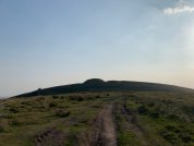
The summit of a lofty mountain spur rising above Risca is enclosed by ramparts with a great castle mound or motte, set at its eastern end. These are the remains of a medieval castle, possibly set within an earlier hillfort. The enclosure circuit describes an elongated oval roughly 330m north-east to south-west by 135m, with an area of 4.14ha. It consists of a high rampart fronted by a ditch and counterscarp bank, set out to take advantage of the natural slopes. Gaps in the west and southern sides have been taken to indicate that the enclosure is unfinished although it is perhaps more likely that these result from later damage. The ground falls steeply away from the ramparts on all sides but the east, where they face onto the level neck of the spur. However, there is a possible approach from the north-west leading to the eastern gap which could be an original entrance.
Significant settlement at Cwmcarn came with Bronze Age migration of local tribes from the Gwent levels to the uplands of Mynydd y Grug, Mynydd Machen and Mynydd Maen (Twmbarlwm) and led to a later Iron Age (900–55 BC) hillfort to be constructed by the Silures on Twmbarlwm.
Roman forces took control of most of what became the Roman province of Britannia Superior in 43 AD but then took a further 25 years to gain control of the present day South Wales valleys. Roman control remained established until full scale withdrawal in the 5th century AD when the Kingdoms of Gwent and Glywysing were established. Gwent was defined as the land between the River Usk and the River Wye and Glywysing, the land between the River Usk and the River Tawe. Cwmcarn, located where the Carn and Ebbw river valleys meet, being situated within the Welsh Kingdom of Glywysing.
Visiting Twmbarlwm
Sites near Twmbarlwm Iron Age Fort
- Rhiwderyn Camp (5 km)
Iron Age Hillfort - Machen (6 km)
Lead Mine, Mine and Minor Settlement - Coed Craig Ruperra (6 km)
Iron Age Hillfort - Croes Carn Einion Roman Villa (6 km)
Villa - Graig-y-Saeson (7 km)
Iron Age Hillfort - Coed y Defaid Camp (7 km)
Iron Age Hillfort - Ffordd Caerleon (Margary Number 60b) (7 km)
Roman Road - Tredegar Fort (Gaer Hillfort) (7 km)
Iron Age Hillfort - The Mount Hillfort (8 km)
Iron Age Defended Enclosures - Lodge Wood Camp (8 km)
Iron Age Hillfort


